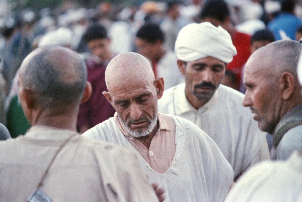
Since the creation of the Peace Corps, the organization has faced the issue of how it could fit the often diverse talents of applicants to the perceived needs of the country in which they would serve. In Morocco, the resolution was neither easy nor successful, and in the first decade of the Peace Corps in Morocco, failure was as common as success. In the Harka article reproduced below, volunteers seem to have found fault with the staff, and its author thinks that greater communication between staff and volunteers might help incorporate knowledge gained first hand to build more successful programs.
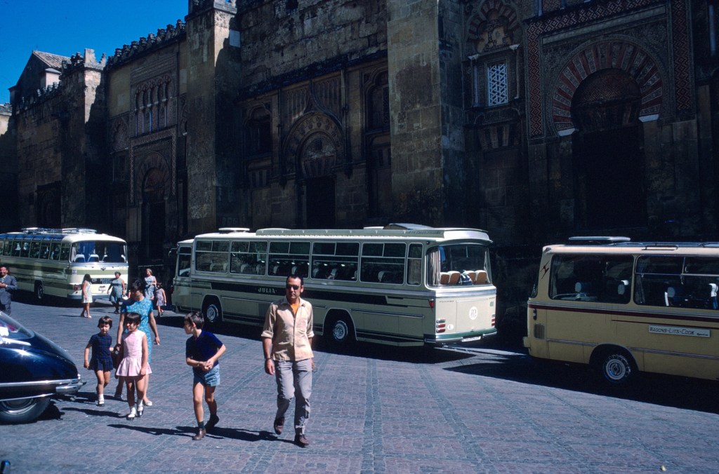
When the article appeared, Morocco X volunteers had just entered the country in 1968, and the author commented on their arrival.
He also offered his opinion that the criticisms of volunteers in Nigeria seemed petty. Having travelled through West Africa at the time, I would argue that they were anything but petty. In places where transportation was slow and difficult and accommodation often nonexistent, hostels and Hondas were important to the volunteers. In Morocco, with much more developed transportation and tourism infrastructures, neither hostels nor motorcycles were necessary. The staff saw motor vehicles as a real danger in Morocco and prohibited them, though that never stopped some Moroccan volunteers from owning a Honda or even a big BMW.
NEW BLOOD
In the January Volunteer article “The oasis in the wasteland”, Donovan McClure sees “hardening of the arteries” in the Peace Corps reflected in the burgeoning of staff numbers and functions. The tasks of the staff have expanded beyond the original ones of “logistics, liaison with ministries and professional support.” Now that the Peace Corps has six years of history it has becone fashionable to look back to find out where and why the Corps has gone astray. Even more so because the Peace Corps is under attack in the U. S., Corpsmen probe the short history for causes of failure.A primary scapegoat is the staff.
Examine for a moment the bulk of the Volunteers outcries directed inward to Rabat. The major “issues” over the past six months seem to have been pay inequities, delayed checks, doctor’s absences and reinbursenent difficulties. Those for Nigerian Volunteers as cited in the Dec. ’66 Volunteer article on Vaughn’s trip to Nigeria were pay, hostels and Hondas. Many of us then newly arrived must have remarked their pettiness. You’d hardly have guessed the country was on the thresho=ld if not in the midst of revolution.
Are our issues more lofty? Vaughn and other administrators addressed Nigerian Volunteers on their problems, but his assessment of the gap between staff and Volunteers concluded that programming and placement were far more important matters. The same two are important in Morocco. We could do well to focus and mobilize support on larger issues and offer more solutions than complaints.
McClure reminds us that Volunteers are responsible for shortcomings, as well as staff. It is often difficult to say whether our staff’s defensiveness is a screen for incompetence in the face of difficult problems or a response to threats from Volunteers. In the area of placement, there has been improvenent. Wait for an evaluation of the ag group program’s to see how staff efforts at programming have fared. Especially in fields already tried in Morocco programming is equally the job of Volunteers. Rural PCV’s have much leeway in prograrming; lab techs and teachers have relatively fixed jobs. A simple report by present Volunteers can be worth many times over time spent when it comes to future placement and planning.
A handful of us, anarchical or independent depending on your point of view, have advocated radical elimination of bureaucratic props such as per diem etc. so as to resemble our VSO counterparts. The staff, however does not recommend its extinction nor do all of us. The present staff has apparently rid itself of much of the past intra-office friction. Also, for better or for worse, it has trimmed its numbers by two…better because one secretary was superfluous, worse perhaps because we are not guaranteed a replacenent for Dr. Bennett once Dr. Shannon departs.
A new staff director will be arriving-(see Garvey biography) an untested quantity. New blood arrived Jan. 17 in the form of 31 men. One of then walked into the Rue Van Vollenhoven office and commented later that he was not impressed with the caliber of Volunteer he saw there. He rationalized that since they were undoubtedly people with problems, they did not represent the best PV’s or they were not in their best mood in the office. A veteran muttered that they were more typical than he thought. Another mused on how many PCV’s and staff were not profitably employed on a given day.
Morocco X is a group of men- of almost men until Morocco seasons them. (Let the untarnished Volunteer Iook at himself in the mirror in a year.) They lack an agricultural background corresponding to their eventual work, but if they are as adaptable as they are intelligent they could well become PC/M’s best asset. Rather than churning further the grimy barrel of complaints it is time to express hope for new trends to the point where we can see the results of our work here and not the ruins of our strife.
In an earlier blog post, I wrote about Oum Kalthoum’s one and only visit to Morocco and her performance at the Mohammed V Theater, which was attended by a group of Morocco X volunteers. Here’s another perspective by a volunteer who, like most Moroccans, watched from a neighborhood café. This account appeared in the volunteer publication, The Harka, in March 1968, and one can access the issue here. My apologies for the poor scan.
OUM KALTOUM
The cafe is already overcrowded. Hardly an empty chair for the diva’s last concert. The bulldog of a proprietor blocks the door grimacing no entry. A friend inside coaxes him and we slide in through the back door. Shoved into a seat, I adjust to the bright screen.
She stands in the center, Oum Kaltoum. From two tiers of ruffles at the foot of her long dress rises the matronly form. In her left hand she holds a thin veil. Both elbows bend at right angles, both held tight to her body. Her middle and index fingers point; sometimes they tap the beat. On her breast is a large diamond brooch and pendant diamonds dangle from her ears. A proud head crowns the body of a proud woman. For a few moments I take her in, feeling in telescoped time the more pronounced hypnotic effect on the rest of the audience.
My host interrupts, ” You understand a little?” “No.” “She is saying, ‘The day goes on after the length of day.’ It’s not hard to comprehend because she speaks so clearly in the highest literary Arabic,” that may be one reason why it is so difficult. I am trained instead to buy food in the market with the fatimas and to scatter shoeshine boys —”and she repeats everything many times.” I am beginning to agree with that but it doesn’t help.
My friends know the words by heart. It is an old song of hers first sung in the late forties. The lyrics come from the last poems of Omar Khayyam. The melody has a base note, what we call a key. The mode is recognizably Egyptian. She loses me in the soaring and descending arabesques. At a point when I think I am sharing the emotions and anticipating the climaxes and the codas, she catches me off guard again.
The contralto voice sings on with scant trace of vibrato, flat by western standards. Her range is not outstanding; the range of dynamics, not dramatic. Her control is good and her stamina excellent. Some people marvel more at her endurance than her dexterity and sensitivity. “She can go on singing for hours without a pause and not a drop of water to soothe her throat. She can go on for fivehours.” Am I there to witness a marathon or to hear music? What can I gain from sitting here?
I remember David Randolph writing, ” ‘Music is a Universal language’…is a misleading adage…Our response to music is largely conditioned by social and ethnic factors.” How could I understand in one night or even one year in Morocco what the Arab boy has heard since childhood. We have been taught something contrary. We consider glissandos which graze notes between half tones unmusical. Egyptian violins sound like whining. The emotional fuses in her music do not ignite us. Likewise play Bach’s Jesu, Joy of Man’s Desiring or some other familiar melody to the uninitiated Moroccan. To such a simple molody we react readily but does he? Then play it in a slightly varied rhythm. He won’t even notice it is “wrong.”
To think I could seize the emotion of Oum Kaltoum was deceptive. Without words came only a vague idea: sad or joyous, grave or playful. Yet are we totally inadequate to appreciate the vocalist both musicaly and extra-musically? My mind stops wandering.
Around and below her sit the orchestral minions: eight violins to her right, three cellos, one plucked bass, bongos and tambourine to her right, and nearest her a horizontal harp instrument and a long vertical flute. The flutist blows sideways: the twitchy harpist eyes her anxiously every moment. The unsynchronized strings bow slithering downward runs. 1 2 3 4 5. Their intensity and pitch mount after she concludes a stanza. 1 and 2 and 1 and 2 and 1 and 2 she climbs the jerky rhythmic stairs. The audience boils. Applause batters her embellishments. She makes a reserved flourish of the hands.
The violins shimmer and she becomes pondersome and she says, “And 15 if I die, where do I go? I want to go… but where? I am in the world without being consulted.” (In the song Omar Khayyam asks pardon for not being pious before. He was first an atheist and converted to Islam in later life.) The joyful tone melts into the seriousness of an affirmation of faith. Gone is the coquettishness.
She repeats of her own will this time, not at the audience’s demand. Often they call on her to repeat again and again, but they insist she never does it the same way Thus she deserves to prolong each song. A change of key is infrequent and changes of rhythm create almost all the increased and reduced tension.
This time the tempo slows to a ripple on the harp. Almost a cadenza, but it is brief and never detracts from the virtuosity of the singer. The cameras make no secret of the fact that she dominates the stage. She has wonderful stage presence. At that instant to most everyone she is sublime.
An hour after the concert began the crowd first becomes restless. Fatigue grows on the faces of the musicians. They question expectantly where and how long she will lead them. In the cafe it is no sacrilege to forget Oum Kaltoum for a minute. Distractions whistle around the smoky glass cage.
A veiled whore knocks at the door but the patron balks. Insisting, she breaks into a scream. She lashes and scratches. He strikes and his fist lands hard. Now she is loose; he dashes out after her by the side way. She disappears. Back to the song. Half an hour later the clientele smirks as she glides by in tow in the other direction.
Another fracas flashes mutely through the panes. A chase. Shadows pass in the dark. The shoeshine boy, frightened eyes agog, presses his nose white against the glass to glimpse an idol. She has finished. Hush! They announce an hour break. That undercuts a little the legend of her stamina.
Midnight. Oum Kaltoum herself sang, “Staying up into the night never killed anyone; sleep never lengthened anyone’s life.” Question the depth of that if you wish. Why not stay for the second song?
Intermission —The News — Another parable in adoration. The king is in Marrakech. Watch him parade through the streets. How broad the avenues, how infinite the crowds. They hail him endlessly. How skillful the cameras. Cut.
A lesson in boredom. A well-intentioned American describes American space ventures in quite good dialect, abominable accent. He takes so long. The viewers pity him. “So long, fellow.” they say when he is phased out to the Tetuan Conservatory orchestra playing Andalusian music with western scales and no harmony. Stiff and correct they say. So does the endless violin solo. Watchers clamor for their lady.
Her time comes. The curtain parts, she crosses her legs a few times and stands. Her song…”Is it true that love is the victor?” the question she asks her lover. “I don’t know, I just don’t know.”She stirs with excitement. She pivots restlessly on her feet like a well-fed ladybird, rooted like a sibyl, too. Sometimes she bobs like a grandmother bird. She is trying to evoke the frustration of a lover. Her gestures are truncated and choppy. Unnoticed the veil changes hands. When she stops the high-pitched string birds all flutter to protect her.
She wields a full arsenal of vocal tricks not to say musical ones. Can the men find a sixty-four year old dowager erotic? Surely it is the heightened suggestion. Lots of nasal m’s and n’s, tantalizing as the end of the line exudes. An unexpected syncopation,…gasp…she wriggles back.
The tenth repetition oozes forth amid wobbles and breathiness. “Aii, Aii ” they cry, “weely, weely, weely. ” They are aroused, déchainés, drunk on the last rendition. Troubled listeners shift position, upset by the extravagint reactions attacking her dignity for she is revered. Every word is haloed and quoted. They say she is being paid 47 million for the three concerts…invitation of His Majesty. The price of the tickets cannot cover. The poor country, the rich music.
“She must have repeated that ten times.” “Sixteen to be exact.” corrects my prompter. Oh…is it so remarkable that she never repeats the same way? Has she stretched the medium beyond its limits? Do the words become trivial or richer through repetition? “Is it true love conquers? I just don’t know. Is it true love conquers? I don’t know.” Which side are you on : infinite variety or diminishing returns?
“She’s dead! ” says one. True the pitch can only fall. The orchestra now uninspired follows on a leash. The cameras enlarge the shadows on the backstage curtains. She will not take an encore. She will take only overflowing accolades and frozen roses to her bosom.
To the door of the cale swings a cripple on crutches. He stares in. Everyone else’s face is vacant, too. They do not see him. He is fast on crutches; that is what he can do. He’s off after a fat man with a pipe. He pleads and clings until he is brushed off like a sticky caterpillar into the street.
By then the creature of charisma has stopped singing. Stranded people soon scatter across the cobblestones, 2:30 in the morning. The night is over as far as they are concerned. No love at this hour. There are many other ways to be conquered. Thank the lady for her spell and the cast of characters of the night.
The other night I watched a “made for Netflix” movie with the title Lonely Planet. The plot involves a love story that begins at a writers’ retreat in Morocco. I had read an online review, and I confess that I would never have given viewing it a second thought but for its location. I was curious about where exactly it was filmed and how Morocco would be depicted.
As it turned out, Morocco was simply a backdrop and Moroccans played no essential role beyond local color. No places were identified by name, but many Peace Corps people could easily point out Marrakesh, the foothills of the High Atlas, the Souss Valley, Essaouira, and Chauen.
The writers’ retreat in the film was in reality a boutique hotel, the Kasbah Bab Ourika, roughly an hour south of Marrakesh in the foothills of the High Atlas. I was surprised when the protagonists get into a rental car and leave for a day excursion, next are pictured in Chauen, and then return to where they began at nightfall. That must have been some one-day excursion! In case your knowledge of Moroccan is fuzzy, the roundtrip drive would have taken a minimum of 16 hours assuming the start was at the Kasbah Bab Ourika. Verisimilitude was not a feature of the movie.
The Kiracofes, Louden and Ginny, and friend. Au sanglier quiz fume, Ouirgane. 1970
In the nineteen sixties, the kind of luxury represented by the writers’ retreat did not exist outside of cities. The Kasbah Bab Ourika was not built until 2004. Travelers were lucky to find any comfort outside of a city, and, if one did, it was most likely a remnant of colonial times such as Au sanglier qui fume southwest of Marrakesh. Just the same, on a cold, windy, rainy night, if one had just arrived, hungry and tired from a long, winding, and unpaved drive over Tizi n Test, Au sanglier qui fume would have offered decent food and a wood fire warming the bedroom. Comfort need not be fancy. Local color consisted of the boar’s head, a pipe stuck in its mouth, that hung over the bar.
Au sanglier’s late owner, Paul Thenevin (white shirt) at breakfast in the courtyard. July 1970.
Cet article a été rédigé par Louden Kiracofe, ami, compagnon d’escalade et médecin à la retraite.
Aissawa à la Fête des cerises, Sefrou. Juin 1968. Photo de Gaylord Barr.
C’est en 1969 que ma femme et moi sommes arrivés à Rabat en juillet 1969 – l’année du premier alunissage – pour un terme de deux ans en tant que médecin du Corps de la paix, chargé de soigner les volontaires répartis dans tout le Maroc. Je voyais chacun d’entre eux au moins deux fois par an pour leur administrer les vaccins nécessaires. En tant que médecin américain, on me demandait souvent de voir des patients marocains et on m’a fréquemment invité à assister à des cérémonies privées rarement vues par des étrangers. Des touristes et des Américains vivant au Maroc me demandaient souvent des conseils médicaux.
Un jour le professeur Vincent Crapanzano m’a contacté au sujet de sa femme, Jane, qui avait consulté un médecin local qui lui avait dit qu’elle souffrait d’une appendicite chronique et qu’elle devait être opérée. À la demande de Vincent, j’ai vu Jane. Après l’avoir examinée, j’ai cru qu’elle souffrait d’une infection bactérienne – la salmonellose – une infection bactérienne courante que de nombreux volontaires (ainsi que moi-même) ont contractée. Je ne pensais pas qu’elle avait besoin d’une intervention chirurgicale (une appendicectomie) et je l’ai mise sous antibiotiques. Elle a rapidement réagi, ils m’en ont été reconnaissants et nous avons commencé à nous fréquenter de temps en temps.
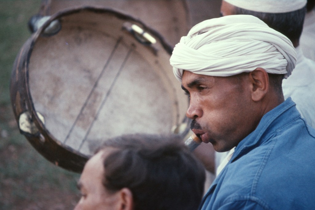
Musicien Aissawa, Sefrou. 1968
Vincent Crapanzano est un anthropologue culturel de renommée mondiale qui effectuait des recherches sur les croyances et les cérémonies de guérison soufies. Par la suite, ses recherches ont été publiées dans un livre : Tuhami : Portait d’un Marocain. Vincent m’a demandé de l’accompagner à une cérémonie de guérison soufie. Il avait déjà assisté à une telle cérémonie et voulait être certain que ce qu’il avait vu était bien réel et non la conséquence d’être dans un état de transe tout comme les soufis qui pratiquaient le rituel. J’ai accepté son invitation sans hésitation.
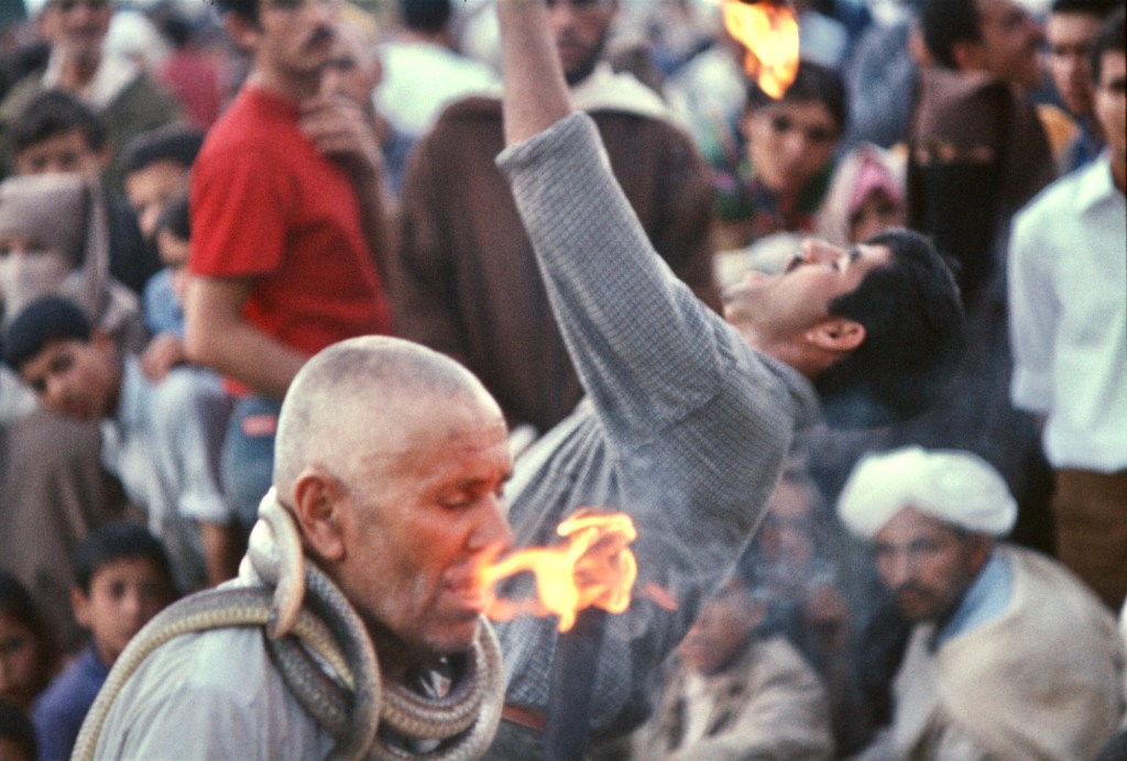
Manger du feu, être mordu par des serpents et danser en transe. Sefrou, 1968.
Un soir à une heure avancée, nous nous sommes rendus en voiture dans un vieux quartier de Rabat, où les touristes ne s’aventuraient pas. Vincent a frappé à une porte et on nous a invités à entrer et à monter les escaliers jusqu’à une petite pièce non meublée qui ne contenait que deux chaises qu’on avait prévues pour nous.
La cérémonie de guérison avait pour but de guérir la jeune fille de l’hôte. Cette dernière, âgée de 8 ans, avait soudainement subi une paralysie du bras droit. On croyait que c’était la conséquence d’avoir offensé un djinn, un mauvais esprit. Selon les normes médicales occidentales, un tel cas de paralysie serait considéré comme une « réaction de conversion ».
Quelques minutes plus tard, une autre porte s’est ouverte et dix hommes vêtus de lourdes djellabas sont entrés. L’un d’eux s’est assis sur un petit tabouret dans un coin avec un tambour. À côté de lui, un homme jouait de la raita, une flûte à anche double au son aigu et strident. Un hibachi aux braises incandescentes a été placé au centre de la pièce et une petite bouilloire a été déposée dessus. Elle commença rapidement à produire de la vapeur. Les autres hommes formaient un cercle et ensuite la cérémonie a commencé. Avec les tambours bruyants et les sons stridents de la raita, le cercle d’hommes a commencé à chanter en avançant en traînant les pieds. Au fur et à mesure que la musique et les chants devenaient de plus en plus forts, plusieurs hommes ont commencé à brandir des jambiyyas (poignards traditionnels courbés) qui avaient été dissimulés dans leurs djellabas. À ce moment-là, il m’a semblé que les hommes étaient en transe. L’hôte s’est positionné de manière protectrice devant Vincent et moi. L’un des danseurs a commencé à taillader son cuir chevelu chauve avec sa jambiyya. Le sang coulait librement sur son visage. Un autre s’est dirigé vers le hibachi, a pris la bouilloire et a commencé à verser l’eau bouillante dans sa bouche. Je pouvais voir de la vapeur qui sortait de sa bouche. Ensuite, un autre a enlevé ses sandales et s’est mis pieds nus sur les charbons ardents, avant de rejoindre les hommes qui traînaient encore dans le cercle.
C’est alors que, sans aucun signal apparent, la cérémonie s’est brusquement terminée. Les hommes ont tous quitté la pièce ensemble et, après quelques minutes, ils sont revenus en tenant des conversations animées les uns avec les autres. J’ai regardé très attentivement et je n’ai vu aucune trace de blessure au cuir chevelu sur l’homme qui avait tailladé son crâne chauve et rasé ; aucune trace d’inconfort chez l’homme qui se tenait pieds nus sur l’hibachi. Soudain, une autre porte s’est ouverte et plusieurs femmes ont apporté de grands plateaux de nourriture. Tout le monde se met à manger et à discuter aimablement, y compris celui qui s’était versé de l’eau bouillante dans la bouche. Il était entendu que la jeune fille malade était guérie. Je n’ai pas eu l’impression d’avoir été en transe et j’ai cru pouvoir vérifier que ce que Vincent avait observé et ce que nous avions vu tous les deux cette nuit-là s’était – bien que presque incroyable –réellement produit.
H. Louden Kiracofe, juillet 1970 au refuge de Lépiney sous le Jbel Tazaghart.
This article has been contributed by Louden Kiracofe, friend, climbing buddy, and retired doctor.
Aissawa at the Cherry Festival, Sefrou. June 1968. Photo by Gaylord Barr.
My wife and I arrived in Rabat in July 1969 – the year of the first lunar landing – for my two-year assignment as Peace Corps physician to care for the P.C. volunteers. The volunteers were situated throughout Morocco. I would see each one at least twice a year to administer required immunizations. As a physician from the United States, I was often asked to see individual Moroccans as patients and was frequently invited to attend private ceremonies rarely seen by foreigners. Often I was sought for medical advice by tourists and Americans living in Morocco. Vincent Crapanzano contacted me regarding his wife, Jane, who had seen a local doctor and was told she had chronic appendicitis and had been scheduled for surgery. At Vincent’s request I saw Jane. After my examination I believed Jane had a bacterial infection – salmonellosis – a common bacterial infection that many volunteers (as well as myself) contracted. I did not believe she needed surgery (an appendectomy) and started her on antibiotics. She rapidly responded. They were grateful and we began to occasionally get together.
Aissawa musician, Sefrou. 1968
Vincent is a world-renowned cultural anthropologist who was researching Sufi beliefs and healing ceremonies. His investigations were later published in a book: Tuhami: Portait of a Moroccan. Vincent asked if I’d accompany him to a Sufi healing ceremony. He had previously witnessed such a ceremony and wanted to be certain that what he’d seen was actual fact (really happening) and not the consequence of his being in a trance along with the Sufis performing the ritual. I readily accepted his invitation.
Eating fire, being bitten by snakes, and dancing into a trance. Sefrou, 1968.
We, one late evening, drove to an old section of Rabat – an area where tourists didn’t venture. Vincent rapped on a door and we were invited in and up the stairs to a small unfurnished room with only two chairs which were for us. The healing ceremony was to heal the young daughter of the host. The 8-year old girl had suddenly suffered a paralysis of her right arm. It was thought to be the consequence of having offended a djinn, a spirit. It would be considered a “conversion reaction” by Western medical standards. Several minutes later another door opened and 10 men clothed in heavy djellabas filed in. One sat on a small stool in a corner with a drum. Seated next to him a man who played the raita, a double-reeded flute with a high pitched, shrill sound. A hibachi with glowing coals was positioned in the center of the room and a small kettle was placed upon it. It quickly began to steam. The rest of the men formed a circle. The playing began. With the loud drumming and shrill sounds of the raita, the circle of men began to chant as they shuffled forward. As the music and chanting grew louder and louder, several men started to brandish jambiyyas (a traditional curved dagger) which had been concealed in their djellabas. At that point it seemed to me that the men were in a trance. The host positioned himself protectively in front of Vincent and me. One of the dancers began slashing his bald scalp with his jambiyya. Blood flowed freely down his face. Another went to the hibachi, picked up the kettle and began pouring the boiling water into his mouth. I could see steam coming from his mouth. Then another removed his sandals and with bare feet stood upon the glowing coals. Then rejoined the men still shuffling in the circle. With no apparent signal the ceremony abruptly ended. The men all left the room together and after several minutes they re-entered having animated conversations with each other. I looked very carefully and saw no evidence of scalp wounds on the man who slashed his shaven bald head; no evidence of discomfort in the man who stood barefooted on the hibachi. Another door suddenly opened and several women carried in large trays of food. Everyone began eating and amiably conversing including the man who’d poured boiling water into his mouth. It was understood that the afflicted girl was healed. I did not have any sense of having been in a trance and believed I could verify that what Vincent had been observing and what we both saw that night had – though almost unbelievable – actually occurred.
H. Louden Kiracofe, July, 1970 in the azib, en route to his first encounter with Jbel Tazaghart.
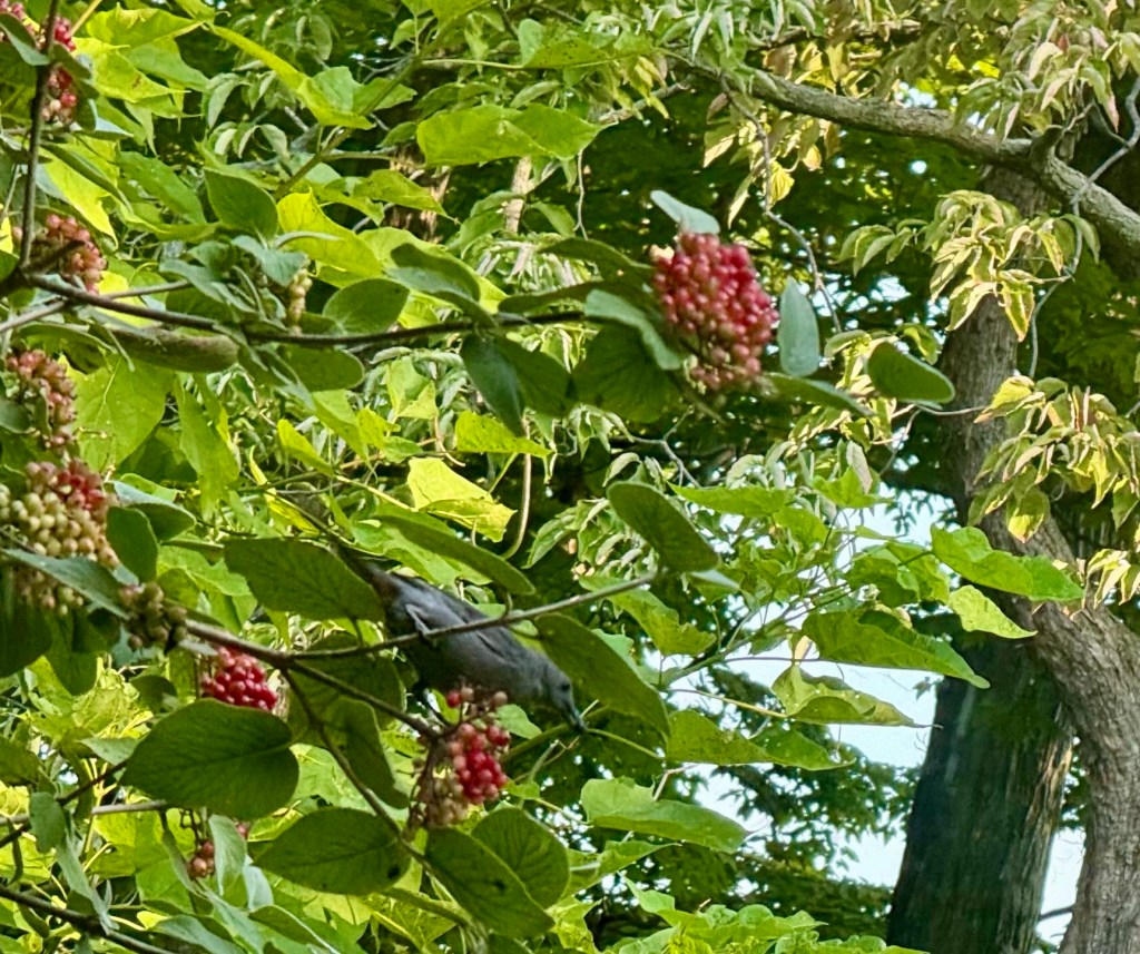
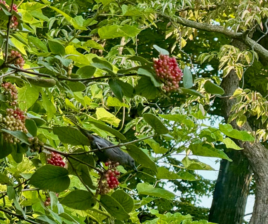
En début de cette belle matinée de juillet, alors que nous sirotions tranquillement notre café au lit, une marmotte traversait la cour et des moqueurs chat effectuaient des sorties pour se nourrir des drupes rouge vif de la viorne située à l’extérieur de notre fenêtre. Pendant ces quelques instants de calme matinal, les problèmes du monde nous semblaient bien loin. Rien dans notre pelouse non tondue ne rappelait exactement le beau poème de Matthew Arnold, mais je ne pouvais éviter le sentiment, partagé par beaucoup, je crois, que le monde se précipite inéluctablement vers un désastre d’une ampleur inimaginable. Mesurez-le à l’aune de la foutaise MAGA si vous voulez, même si la vacuité de Trump, l’ignorance, la démagogie, la cupidité et le pouvoir des élites qu’il embrasse ne peuvent se comparer aux véritables problèmes auxquels l’humanité est confrontée.
Le moqueur chat picore les baies
Dresser une liste exhaustive des catastrophes en cours et à venir remplirait facilement une page, mais, tout comme Brassens a pu chanter sa guerre préférée, je peux énumérer mes préférées, celles qui m’inquiètent le plus : le changement climatique, encore nié par beaucoup, la pollution sans répit de l’humain, invisible et insidieuse, l’extinction massive à une échelle et dans un délai qui n’ont d’égal que celle causée par la météorite de Chicxulub, la prolifération nucléaire, qui paraît irréelle aux yeux des Américains qui n’ont jamais vécu la destruction occasionnée par la guerre en Europe et au Japon, l’aggravation des inégalités et de la faim, à une époque de richesse et d’abondance immenses, l’intolérance religieuse croissante partout dans le monde et l’utilisation grossière, odieuse et finalement immorale de la force militaire, à des fins discutables et sans tenir compte de l’énorme souffrance des innocents.
Dans son poème, Arnold déplorait le recul de la foi et cherchait du réconfort dans l’amour, ce à quoi on n’aurait rien à redire;cependant, Arnold vivait à une époque d’optimisme où l’on accueillait le progrès comme faisant naturellement partie de l’avenir. Pour moi, cependant, la retraite que j’aperçois est celle de la foi en la raison. J’ai récemment terminé l’ouvrage de Stacy Schiff, Une grande improvisation, Franklin, France et la naissance de l’Amérique, qui relate la période de la vie de Benjamin Franklin en tant que commissaire des colonies américaines en France, qui faisait de son mieux pour obtenir une aide financière et militaire de la part du gouvernement de Louis XVI. Le séjour de Franklin à Paris a marqué la fin de l’âge de la raison, rapidement suivi d’une Révolution qui a donné le coup d’envoi à une nouvelle religion : le nationalisme.
Depuis l’époque de Franklin, le nationalisme et les religionsanciennes ont rivalisé avec la raison pour conquérir l’esprit et le cœur des hommes. On ne peut qu’espérer…et prier…pour que les actions des hommes soient tempérées par un mélange adéquat des deux, et guidées par une puissance qui soit supérieure à l’intelligence artificielle. L’internationalisme, selon la façon dont on l’envisage, s’avère un puissant antidote au nationalisme. Malheureusement, les Américains, qui ont inondé le monde entier de leur culture, tendent à avoir l’une des cultures les plus insulaires, et la xénophobie et l’isolationnisme sont présents dans notre pays depuis sa création. Seules des menaces imminentes et existentielles semblent inciter les Américains à s’engager à l’étranger. Pourtant, aujourd’hui, quels que soient les critères retenus, les Américains, confrontés à de nombreuses menaces de ce type, font preuve d’une complaisance remarquable. Obnubilés par les multimédias, beaucoup ont perdu l’art de la réflexion.
La viorne est originaire de l’hémisphère Nord, y compris des montagnes de l’Atlas au Maroc, et se cultive souvent dans les jardins aux États-Unis. Les baies rouges sont comestibles, mais ont mauvais goût. Certaines sont légèrement toxiques. Cependant, la couleur rouge vif est attrayante et la plante occupe une place et une signification particulières dans la culture ukrainienne. Les Russes la célèbrent également, et une chanson russe populaire du XIXe siècle, Kalinka, lui est consacrée. Lorsque j’étudiais le russe au lycée, le professeur se servait de la chanson pour enseigner la prononciation et le vocabulaire, ainsi que pour rompre la monotonie de l’apprentissage des conjugaisons et des déclinaisons. Bien des années plus tard, même si j’en ai beaucoup oublié, je me souviens encore du vers, В саду́ я́года-мали́нка, мали́нка моя́, « Mes belles baies dans mon jardin ».
Aussi beaux soient-ils, le moqueur chat et les baies ne parviennent pas à chasser de mon esprit les images d’innocents morts et affamés. Mon vieil ami d’université, Jim, croit que arriver à un consensus sur le changement climatique pourrait aider l’humanité à partager les valeurs importantes que nous avons tous en commun, et peut-être que cela se produira à mesure que les effets du changement climatique deviendront indéniables malgré la désinformation répandue depuis bien des années par les industries des combustibles fossiles. Je l’espère.
Early on this beautiful July morning, while we sipped our coffee in bed, a groundhog munched her way across the yard and gray catbirds flew sorties to feed on the bright red drupes on the viburnum outside our window. For those few moments in the early morning quiet, the problems of the world were far away. Nothing in that unmowed lawn exactly recreated the Matthew Arnold moment, but I could not the avoid the sense, shared with many I believe, that the world is careening away toward a disaster of unimaginable magnitude. Measure it by MAGAturd if you like, though the bathos of Trump, the ignorance, demagoguery, greed, and elite empowerment it embraces, can’t compare to the real issues facing humankind.
The catbird in the viburnum
Creating an exhaustive list of ongoing and future disasters would easily fill a page, but I can list my favorites, just as Brassens could sing about his favorite war. Of the issues that worry me the most are: climate change, still denied by many, unabated manmade pollution, invisible and insidious, mass extinction on a scale and in a time frame only equaled by that caused by the Chicxulub meteorite, nuclear proliferation, unreal for Americans who have never suffered the war-made destruction of Europe and Japan, widening inequality and hunger in an age of tremendous wealth and plenty, growing religious intolerance across the world, and crass, abhorrent and ultimately immoral use of military force, for questionable ends and without regard to the enormous suffering of innocents.
Arnold bemoaned the retreat of faith and sought solace in love, and nothing wrong in that, but Arnold, despite his pessimism, lived in an age of optimism when progress had come to be accepted and expected as part of the future. For me, though, the retreat I hear, the shingles on my beach, is one of faith in reason. I recently finished Stacy Schiff’s A Great Improvisation, an account of the period of Benjamin Franklin’s life as a commissioner for the American colonies in France, doing his best to secure financial and military assistance from the government of Louis XVI. Franklin’s time in Paris marked the very end of the Age of Reason, to be quickly followed by a revolution that spawned a new religion: nationalism.
Since Franklin’s time, nationalism and traditional religions have competed with reason for the minds and hearts of men. One can only hope–and pray–that the actions of men will be tempered by a proper mixture of the two, and guided by some power higher than artificial intelligence. Internationalism is a powerful antidote to nationalism. Unfortunately, Americans, who have spread their culture around the globe, tend to have one of the most insular of cultural viewpoints. Xenophobia and isolationism have been with this country since its inception. Only imminent and existential threats seem to generate American involvement abroad, yet today, by any standard, Americans faced by many such threats, are remarkably complacent. Besotted by multimedia, many have lost the art of reflection.
The viburnum in my yard is native to the Northern Hemisphere including the Atlas Mountains of Morocco, and often planted in gardens in the US. The red berries are edible, but they taste bad. Some are mildly poisonous. The brillant red color is attractive, however, and the plant has a special place and meaning in Ukrainian culture.
The Russians celebrate it, too, and a popular 19th century Russian song, Kalinka, is dedicated to it. When I studied Russian in high school, the instructor used song to teach pronunciation and vocabulary as well as to break the monotonous learning of conjugations and declensions. Years later, when I have forgotten much, I still remember the verse, В саду́ я́года-мали́нка, мали́нка моя́, My beautiful berries in my garden.
Beautiful though they are, the catbird and the berries can’t keep the images of dead and starving innocents long out of my mind. My old college friend, Jim A, thinks that a consensus on climate change might help humanity share the important values that everyone has in common, and, perhaps it will as the effects of climate change become undeniable in spite of the misinformation spread for years by the fossil fuel industries. I hope so.
In his recent debate with Donald Trump, Joe Biden alienated alley cats the world over by accusing Trump of behaving like one. “You have the morals of an alley cat,” pronounced President Biden with scorn. The backlash was immediate and fierce.
“I might be an alley cat, but I’ve never had to resort to a purrnstars for sex,” said one Tom. Another, Minou, from Paris, lamented that some anglophones might confuse being a “félin” with being a felon. Moucha, from Sefrou, said Trump’s Access Hollywood remarks to Billy Bush on grabbing pussies still gave her nightmares.
Cats do not have the right to vote, so Biden’s offensive comment will have no effect on the 2024 election, but his remarks certainly elicited much comment around the kibble.
Trump brushed off the comment, contending that everything that he has ever done is purrfect, and, in any case, the only animals of concern to him were sharks and he would like to kill them all.
In Morocco, cats are regarded in a manner as kindly as possible in a country where many individuals have to scramble to eke out a living and put food on the family table. While living there, I heard stories about the prophet Mohammed and cats including the following which may be apocryphal, but certainly widespread:
“The Prophet had a favourite feline. She was called Muezza, and there’s one well-known story of both of them. One time, when the call to prayers was heard, Muezza was asleep on one of the Prophet’s robes. Rather than disrupt Muezza’s slumber, the Prophet cut off part of his sleeve to leave him in peace. Throughout his life, the Prophet was seen to always practise immense care for Muezza.” (HalalZill)
According to Wikipedia, cats enjoy a special status:
“The cat is considered “the quintessential pet” by Muslims, and is admired for its cleanliness, and was a beloved animal to Muhammad. Unlike many other animals, such as dogs, Islamic Law considers cats ritually pure and possess baraka (blissful energy), and allows cats to freely enter homes and even mosques. Although cats are ritually pure, their flesh is forbidden. Cats are believed to be the most common pet in Muslim countries.”
“In Islamic tradition, cats are admired for their cleanliness. They are considered to be ritually clean, and are thus allowed to enter homes and even mosques, including Masjid al-Haram. Food sampled by cats is considered halal, in the sense that their consumption of the food does not make it impermissible for Muslims to eat, and water from which cats have drunk is permitted for wudu (the ablution that is done by Muslims). Furthermore, there is a belief among some Muslims that cats seek out people who are praying.“
I remember the cats of Morocco fondly. Street cats were common. One night in 1973, on my way to a home in the Oudaïa on Rabat, I came upon a cat and a rat, facing off in the middle of a narrow and dark alleyway. The former sat on his haunches, waiting for his prey to make a move to escape. As I was late, and hurrying, I never saw how that encounter with the rat ended, but I suspect that the cat had a big meal that evening.
Incidentally, that rat was the only one that I ever saw in Morocco, bar one other: moving into the Seti Messaouda house, as I entered the house for the first time, I saw a rat quickly disappear into the hole of the squat toilet in the bathroom. It evidently was able to swim through the sewer system, and it never reappeared as the Merrycat, who had adopted me at the primary school, and moved in to become the resident feline.
The following small gallery of old photos of Moroccan cats.
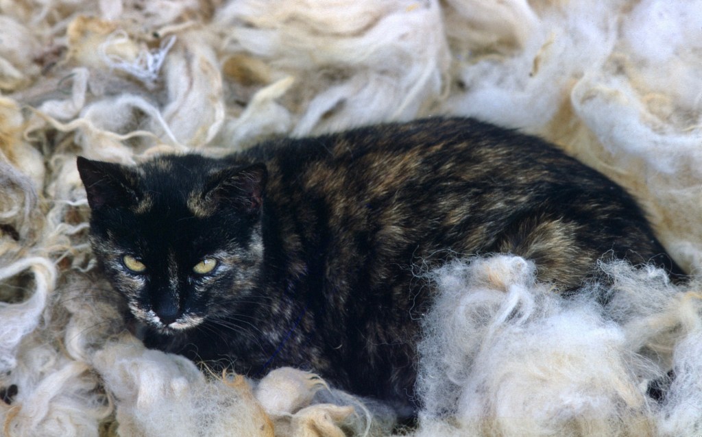
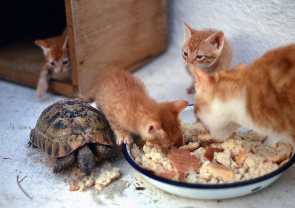
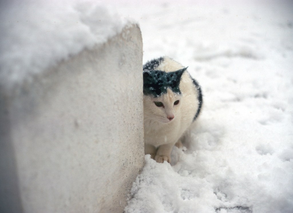
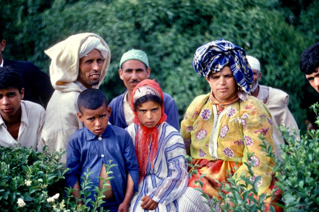
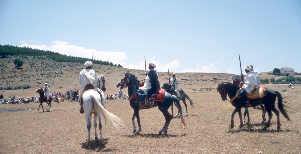
Cat in the medieval Bou Inania medrasa Fes in Morocco 1970Cats seek out the warmth of the sun and the peace of this Merinid monument, like the boys in the corner of the courtyard, while men enter to make their ablutions. 1970Cats hang out at the pool of Lalla Chella in Rabat. In Merinid times it was a part of a mosque complex, that has since collapsed. Filled by water from the “Spring of Paradise”, the pool is inhabited by eels to whom local women feed eggs. The cats look for scraps. This photo dates from early January, 1968. Morocco X volunteers had just entered the country.Merrycat in freshly washed wool on the terrace of my house. My first cat, she came from the school. 1968The three Sefrou cats, Samira, Hamara, and Abderrahman rest in my bedroom. When Merrycat died, Khadija kept bringing kittens until she decided that there were enough. 1969Samira on the banquettes in the front room. 1969Hamara and Samira calmly watch goings-on in the street below. 1969Hamara’s kittens and the pet tortoise share some hearty Moroccan bread and milk on the terrace. Hamara had a close call early in her life. When hunting lizards along the city wall, which abutted the terrace, she fell into the street that ran along the wall. One of the shopkeepers knocked on the door and alerted Khadija. She promptly rescued the terrified cat. 1970Samira on the terrace after a rare snowfall. 1969AbderRahman emigrated to America with one of his kittens, and lived out his lives in Yakima. Photo by Gaylord Barr 1973
Nine years ago, an old Peace Corps friend, Gaylord Barr, passed away unexpectedly. In those days, I knew him as well as anyone. We shared a house for almost four years as well as many adventures and joint travel.
I thought that I would remember him to his friends on this, the day he died, with a few photos labeled with his own commentary from emails he sent in the last years of his life. Gaylord had a great sense of humor, a blend of silliness, self-deprecation, irony, and mild sarcasm. If he’s watching somewhere, he will surely get a chuckle from his remarks—or mine.
The pool of eels in the Chellah in Rabat, below this text, is a favorite both of women who feed the fish eggs and of the many cats that beg and scrounge scraps from them. Vendors would sell hard boiled eggs to visitors.
“The shoe salesman at the Bon Marche in Yakima had insisted I buy those boots because ‘There are a lot of snakes in Africa…’ Made sense to me. Several Morccans offered me the djellabas off their backs for those boots. I should have taken them up on it.” 1968“Memories of the Pyrenees still sometimes tug at my heart and brain. I would love to be ‘in them’ right now…but I couldn’t take the hiking we did all those decades ago. I’m thinking Paris next summer.” El Parque de Ordesa y Monte Perdido, Spain. 1969“I make friends when I’m living in other countries.” The sheep lived for a time on our roof, being fattened for Aïd el Kebir. Terrasse of the Setti Messaouda medina house. 1970But I’ve never discovered the secret of making them in the U.S. Here I’m shy.” Sheep loved him wherever he went! Resting in the azib on the way to Tazaghart. High Atlas. 1973“In the photo of me with Marc and Phil, I look like I’m 12 years old.” None of us were very old. Gaylord was just 21. Sefrou. 1968“My room in our house looks a little more austere than I remember. Still, I loved it, and I loved the house. Coincidentally, I found that decorated map that hung on the wall in my Mom’s old cedar chest just last weekend.” The front room of the Sefrou medina house. 1970“Torla! Ah…some of the best meals I’ve had in all my life. Struggling to get up the ice/snow wall with my Country Store Yakima boots.” From Torla to Gavarnie via the Brèche de Roland. El Parque Nacional de Ordesa y Monte Perdido, Spain. 1969“The Bouiblane snow and the flowers are lovely. I can smell that country now as I write…that mix of woodsmoke, flowers, and goat droppings.” In the hills above Sefrou, riding a mokhazni’s horse. 1968“When I picture Marc, he’s wearing that red and black jacket.” Atop the Tour Hassan. Rabat. 1968Tunis. 1971
I’m sure Gaylord would have chided me for omitting pictures of his Sefrou friends and students. That’s for next year.
Récemment un lecteur marocain de ce blog, qui m’écrivait de l’Alberta, m’a demandé si j’avais des photos que je pouvais partager de la fête des cerises.
Le Maroc, spectaculaire par sa beauté naturelle, est également un pays de spectacles. Quant à moi, le festival folklorique de Marrakech vient immédiatement à l’esprit, ainsi que les diverses célébrations de saints hommes et de confréries religieuses. Ceci étant dit, il existe au pays de nombreux festivals plus modestes et moins connus. Parmi eux, le festival des cerises de Sefrou, dont le premier date de 1920, est le plus ancien.
Sefrou, à seulement 28 kilomètres au sud de Fès, possède l’une des fêtes locales les plus connues, la fête des cerises. Cette ancienne ville, très proche de Fès, est traditionnellement le dernier endroit véritablement urbain au sud de Fès, sur une route autrefois connue sous le nom de treq es-sultan, soit la route du roi. Une grande route suit l’ancien itinéraire des caravanes, traversant le Moyen Atlas, descendant dans les plaines de la haute Moulouya, puis remontant pour traverser le Haut Atlas et aboutir à Tafilelt, berceau de la dynastie alaouite, à l’extrême limite du Sahara. Aujourd’hui, les touristes empruntent cette route pour atteindre les impressionnantes dunes de sable d’Erfoud, et les camionneurs transportent leurs cargaisons de produits manufacturés, de dattes et de safran vers et depuis Fès, en bravant les routes glissantes et enneigées des plateaux du Moyen Atlas.
Table d’orientation palais jamaï Fes : Cette table d’orientation, objet typiquement français, se trouvait dans les jardins de l’hôtel Palais Jemaï, sur les hauteurs de la ville de Fès, et indiquait les points de repère importants vers le sud. Une vue de l’Oued Agaï représente Sefrou, mais après l’inondation de 1950, la ville aurait pu être mieux symbolisée par ses jardins–ou ses cerises.
La ville, qui abritait autrefois une très importante communauté juive, est aujourd’hui visitée par de nombreux touristes juifs depuis l’établissement de relations diplomatiques entre le Maroc et Israël. Il existe plusieurs sites Internet consacrés aux Juifs de Sefrou, et la ville elle-même remonte à l’époque de la fondation de Fès, ou peut-être même plus tôt.
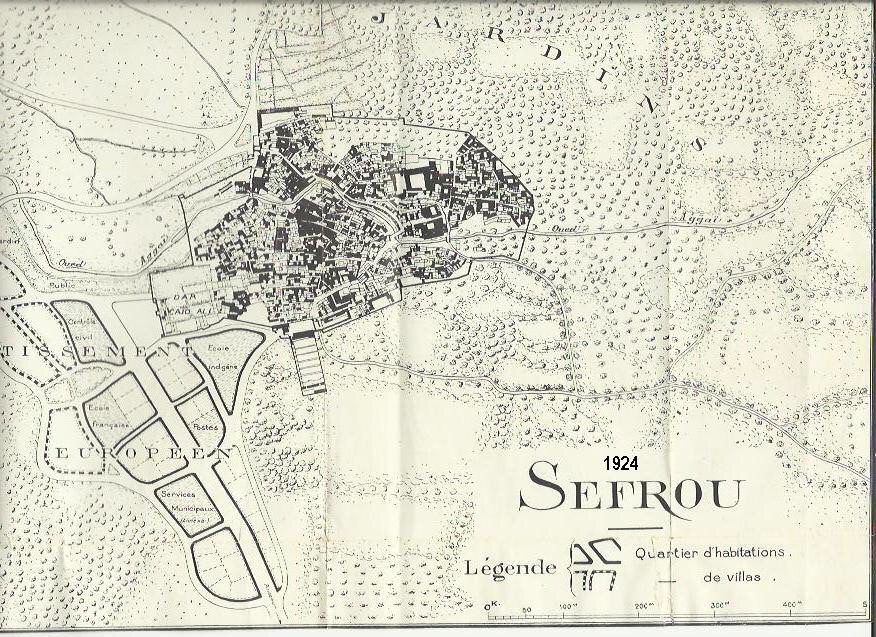
« Une ville enfouie dans les arbres » Carte postale ancienne avec une partie de la Kelaa au premier plan à gaucheUn plan ancien de Sefrou montre presque toutes les structures de la ville enfermées derrière son mur défensif. Les Français développaient la zone située à l’extérieur du mur, à l’ouest, pour eux-mêmes. Ma maison, à l’intérieur du mur, n’avait pas encore été construite et son emplacement était encore un jardin. Plan de la ville de Sefrou. 1924
Peu de temps après mon installation à Sefrou en 1968, j’ai assisté pour la première fois à la fête des cerises de Sefrou. Gaylord Barr se trouvait déjà à Sefrou, où il travaillait à l’un des centres de travaux agricoles du ministère de l’agriculture, et Jerry Esposito enseignait l’anglais au lycée qui venait d’ouvrir, bien que Jerry ait peut-être déjà terminé son service et quitté le pays en juin. Carolis Deal et John Abel, qui avait initié dans une école primaire le poulailler dont j’ai pris la responsabilité, étaient eux aussi déjà partis.
Plusieurs autres volontaires se sont pointés à Sefrou pour participer cette année-là : Phil Morgan, Marc Miller et Steve Boeshar. Gaylord Barr, Marc Miller, et Phil Morgan, tous volontaire au sein de la cohorte Morocco X. 1968
La proximité de Sefrou avec Fès et la facilité d’accès ont fait du festival des cerises une attraction régionale majeure et, comme des volontaires demeuraient déjà à Sefrou, trouver du logement n’a jamais posé de problème.
Jan, Ruth et Gaylord ont tous trois enseigné l’anglais au lycée. Pendant le festival de 1970.
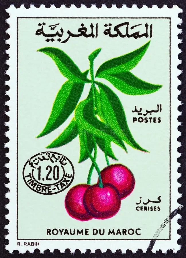
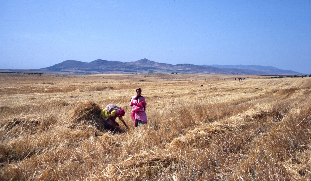
Je ne savais pas grand-chose de cet événement, si ce n’est qu’il mettait en vedette les cerises. Les Marocains appellent les cerises hab el-moulouk, ce qui signifie l’amour des rois, et la variété locale, el-beldi, est réputée pour être particulièrement sucrée et savoureuse. Sefrou occupe une dépression montagneuse à une altitude suffisamment élevée pour que les cerises y prospèrent, mais la ville comptait de nombreux autres fruits et légumes dans les anciens jardins qui l’entouraient. Dans les vergers qui entouraient la ville, poussaient des oranges, des grenades, plusieurs variétés de figues et de nombreux oliviers. Personnellement, j’ai préféré les fraises locales aux cerises.
Cueillette de fraises au printemps. 1968Ce champ se trouvait seulement à quelques minutes de marche de la médina. 1968Cueillette de fraises avec Mohammed Chtatou et Ali Azeriah. À noter les oliveraies. 1970
De nos jours, la population de la ville a connu une augmentation fulgurante, doublant depuis l’époque ou j’y ai vécu, et la zone bâtie s’est étendue bien au-delà des murailles de la vieille ville. Cette croissance a surpris Gaylord Barr qui a fait un arrêt à Séfrou lors de son retour de l’Arabie saoudite en 1997. Dans mon souvenir, les zones extra-muros, à l’exclusion de la ville nouvelle, se limitaient essentiellement aux quartiers de Derb el-Miter, Habouna et Seti Messaouda. Je fais cette digression sur la démographie et l’urbanisation de Sefrou avant l’étalement urbain pour souligner à quel point il était facile de sortir de la médina et, en quelques minutes, de se retrouver dans les jardins qui entouraient la ville. Le vendredi, les femmes se promenaient en groupes, leurs petits enfants à la main, pour pique-niquer dans les vergers, manger des fruits frais, prendre l’air et, bien sûr, bavarder autour d’une tasse de thé. J’ai apprécié la proximité de la campagne et je faisais fréquemment des promenades au village avoisinant de Bhahlil, célèbre pour ses habitations troglodytiques.
Vue du village de Bhalil vers le sud, en direction de la plaine du Saïs et de Fes. 1969
Promenade aux jardins, le long du mur de l’ancien cimetière juif. 1969
On parlait de Sefrou avant l’inondation. Je me demande s’ils parlent aujourd’hui de Sefrou avant l’étalement urbain, l’époque où tout le monde, à l’exception des riches, des puissants et des étrangers, vivait dans la médina et autour d’elle. Les jardins et les vergers de Sefrou caractérisaient la ville à cette époque, et les voyageurs la comparaient parfois à une oasis.
Vue vers le sud-est. Le cimetière juif est situé en bas à gauche de la photo. Sefrou occupe un bassin dont la majeure partie est entourée de collines. 1969
Le terme moussem a été utilisé pour décrire le festival, mais d’après ce que j’ai pu comprendre, la fête des cerises, créée vers 1920, se célébraient plutôt comme une foire agricole au sens européen ou américain du terme. Le mot moussem a souvent le sens d’un pèlerinage religieux sur la tombe d’un saint local, pratique fréquente au Maghreb. Il y avait plusieurs zawias, ou confréries religieuses, à Sefrou, ainsi qu’un marabout et quelques lieux sacrés aux yeux des habitants, mais je n’ai assisté à aucune célébration religieuse régionale de l’importante de celles que l’on trouve à Moulay Bouchta ou à Jbel Alam. Le festival des cerises est apparu comme un événement uniquement séculier dans un pays où la religion imprègne généralement la plupart des cérémonies publiques. La sélection d’une « Miss Cerise » et le défilé de la jeune femme m’ont semblé en contradiction avec les valeurs de l’islam.
Il y avait, bien sûr, les habituels dîners sous tente pour les dignitaires locaux que l’on trouve lors de toute célébration publique marocaine, ainsi que des marchands ambulants qui offraient toute sorte d’articles, de nourriture, de sucreries et de boissons. Les gens circulaient dans la ville nouvelle.
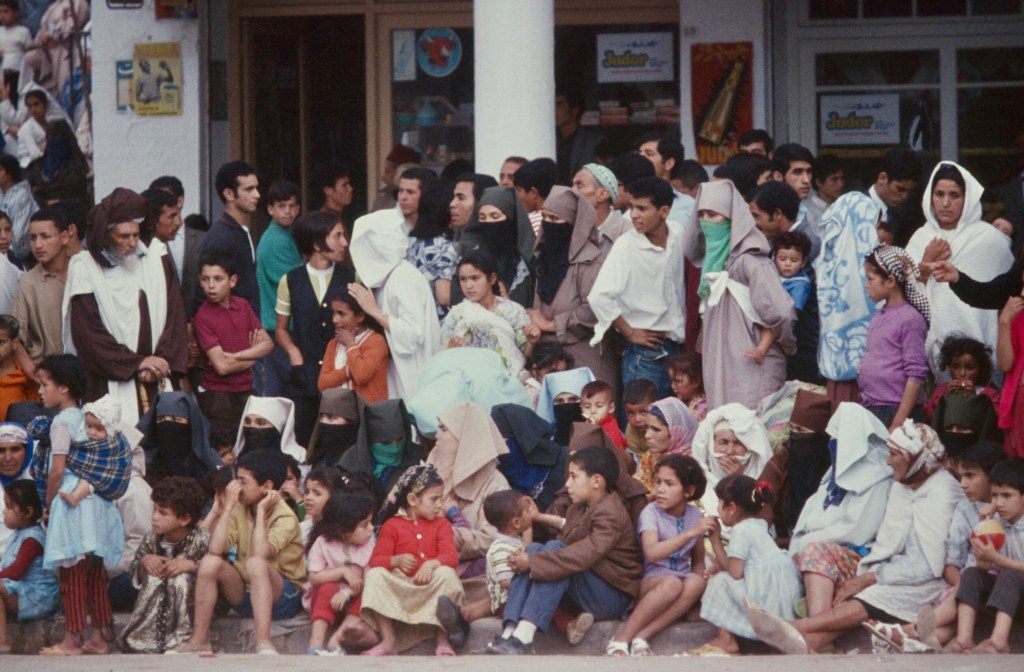
Femmes se reposant à l’ombre. 1968Promenade parmi les tentes au bord de la ville nouvelle. 1968Un porteur d’eau fait le plein à un robinet public. 1968Différentes générations se regardent. 1968Gaylord se mêlant à une foule d’enfants……et discutant avec un cavalier berbère de sa monture. 1968Les manèges offraient un plaisir particulier en dehors des grandes villes. 1968Le long de la rue principale de la ville nouvelle, les gens se sont rassemblés pour regarder le défilé. 1970 ou 1973La rue principale lors d’une journée d’été plus typique. L’effervescence de la vie urbaine régnait dans la médina et aux alentours. La ville nouvelle s’étendait sur les pentes à droite. Tout en haut, un fort français, des casernes et un marabout. 1969
Un jury composé de personnalités locales sélectionne une Miss Cherry, qui défile dans la rue principale de la ville nouvelle à bord d’un char. L’un des chars de cette première année comportait également des danseurs qui se produisaient au fur et à mesure du défilé.
Danseurs professionnels du Moyen Atlas. D’après de nombreux Marocains, la danse ne constituait qu’une de leurs professions.Photo prise par Gaylord Barr. 1968Les danseurs avec un musicien, à l’extérieur de la tente des notables. 1968Danser pour la foule. Photo par Gaylord Barr. 1968Les spectateurs 1968
Le défilé comprenait l’exhibition publique d’une femme, ce qui est tout à fait inhabituel dans un pays où les femmes se couvrent en public. La foule qui se pressait le long de la rue principale de la ville nouvelle faisait preuve de curiosité.
Les foules le long du parcours du défilé étaient denses et composées principalement de femmes et d’enfants. 1973Le char du ministère de l’Agriculture 1970
.
L’affiche sur le char allégorique présente les avantages des charrues modernes. 1970Un porteur d’eau offre des boissons à la foule. 1973Miss Cherry. 1969 ou 1970Femmes et enfants assis le long du trottoir. 1973
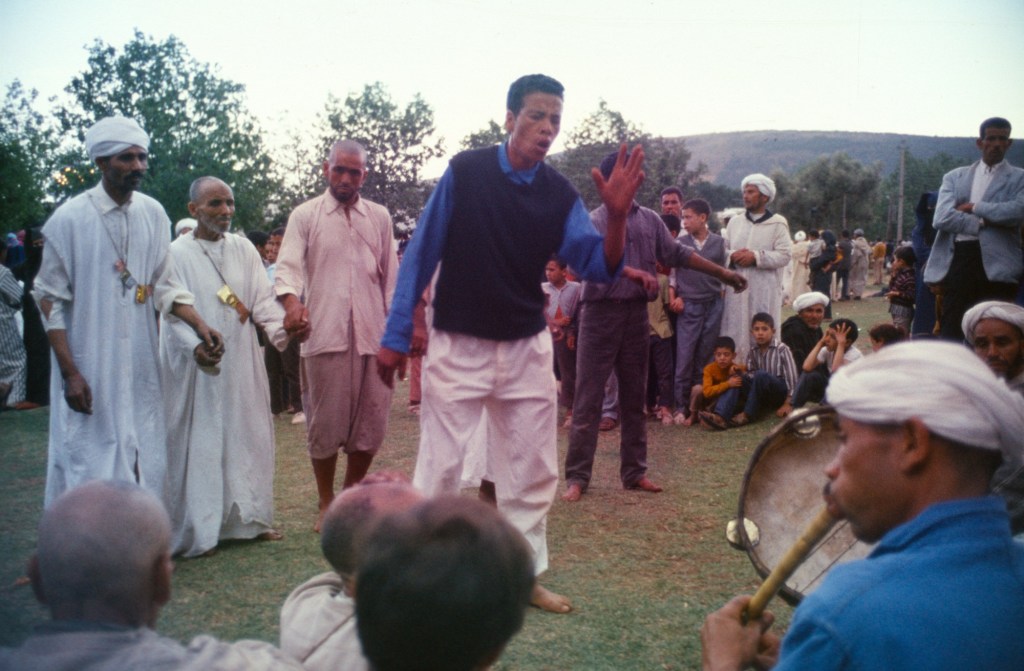
Le festival donnait l’occasion aux confréries religieuses de se réunir et de se livrer à leurs activités particulières, peut-être comme un divertissement pour les spectateurs, mais comme un rituel sérieux pour les participants.
J’ai toujours appelé ceux que j’ai vus Aissawa, ce qui aurait fait d’eux des membres de la confrérie soufie centrée à Meknès. Il existe à Meknès un grand sanctuaire avec un mausolée où repose le maître soufi Ben Aissa, également appelé shaykh el-kamal, le chef parfait. Un important moussem s’y déroule chaque année le jour de la naissance du prophète Mahomet, le Mouloud.
La cour devant le sanctuaire à Meknès à l’occasion du Mouloud 1976Partie d’une procession Aissawa à Meknès 1976
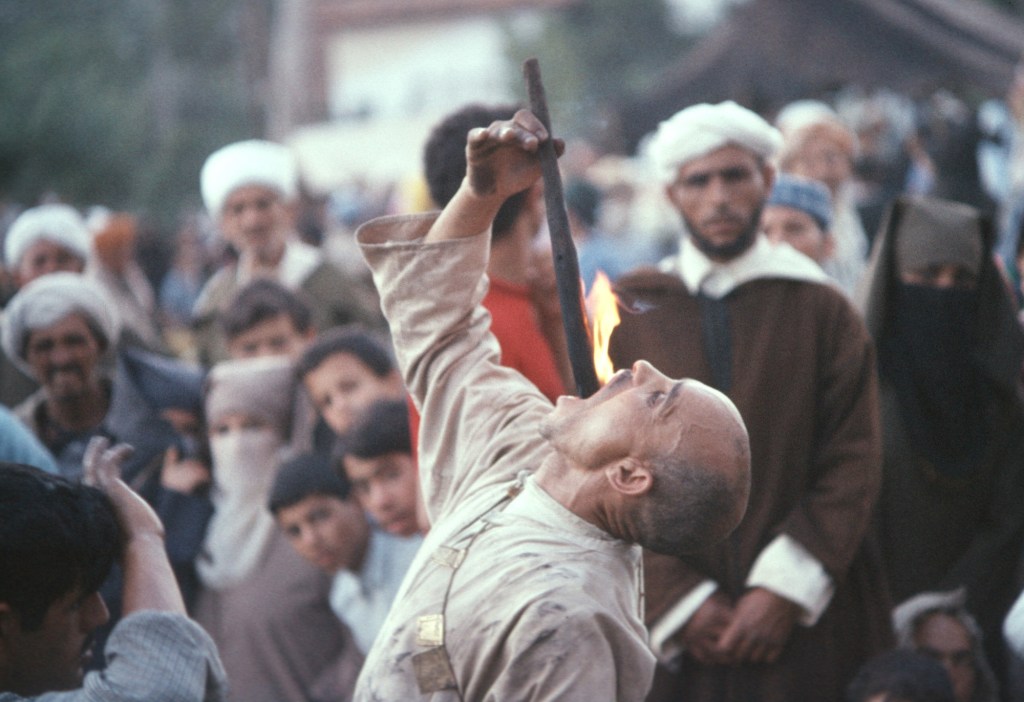
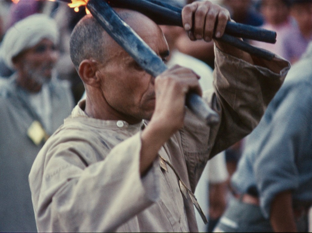
Lors du premier festival des cerises auquel j’ai assisté, un groupe d’Aissawa ou, peut-être, d’Hamadsha, qui mangeaient du feu et manipulaient des serpents mordants, ont dansé jusqu’à l’état de transe. Quelques-unes des photos montrent les visages écarquillés des spectateurs : ces spectacles étaient loin des rituels formels de l’islam de tous les jours !
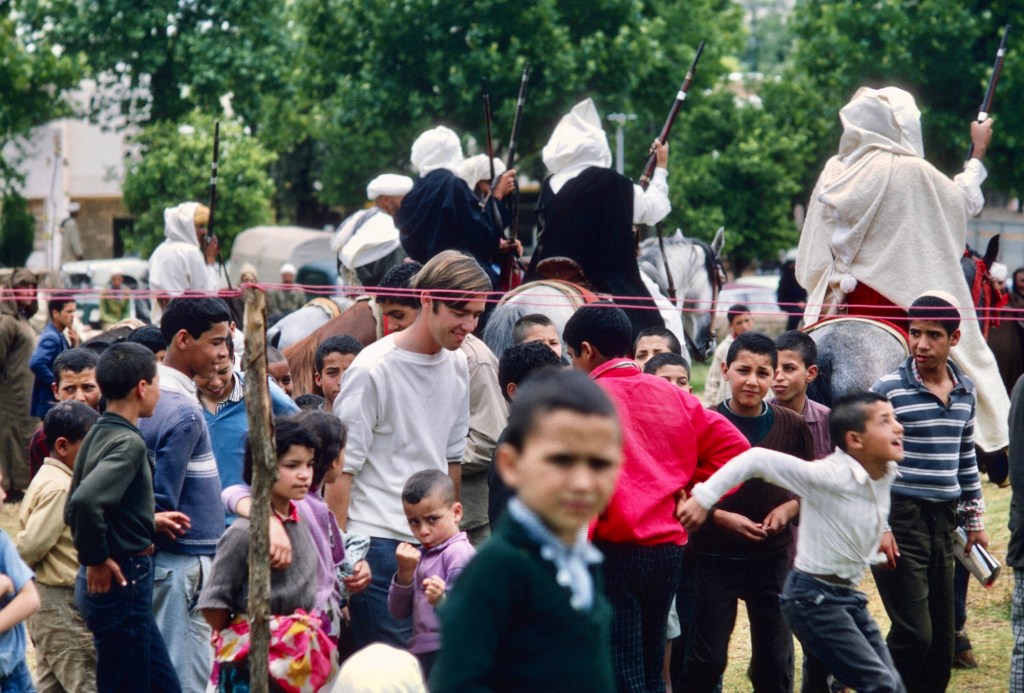
Les hommes dansaient en cercle, en chantant et en se frappant la poitrine. Photo de Gaylord Barr. 1968.L’un des musiciens. Photo de Gaylord Barr. 1968Les instruments étaient tous traditionnels. 1968Les danseurs se relayaient pour se produire au centre du cercle. La plupart de ces photos ont été prises sur un film Kodak Ektachome. Cette photo a été bâclée lors du développement : le centre de l’image ne devrait pas être rose. Aujourd’hui, prendre des photos est D’une grande simplicité et, les pellicules n’étant plus utilisées à grande échelle, les appareils photo électroniques et les téléphones cellulaires peuvent capturer et stocker une quantité impressionnante d’images. Je prenais soit 20 ou 36 photos sur un rouleau de film, le film coûtait cher et sa sensibilité se limitait aux conditions lumineuses. 1968Chants et danses. Les amulettes portaient des inscriptions religieuses. 1968…à mesure que la musique continuait……la danse continuait. L’homme à droite a des serpents drapés autour du cou. 1968Manger du feu faisait partie du rituel. J’adore le regard des spectateurs. Le groupe a commencé par demander à la foule des contributions ou des dons. 1968Feu et serpents. 1968Le feu était réel……et les serpents étaient sans l’ombre d’un doute bien réels. Je voyais le sang qui suintait des piqûres de serpents. 1968Certains portaient des serpents et mangeaient du feu. Le spectacle était envoûtant et, si je n’avais par été occupé à prendre des photos, mon visage aurait pu montrer autant d’attention que celui des spectateurs sur ces photos. 1968
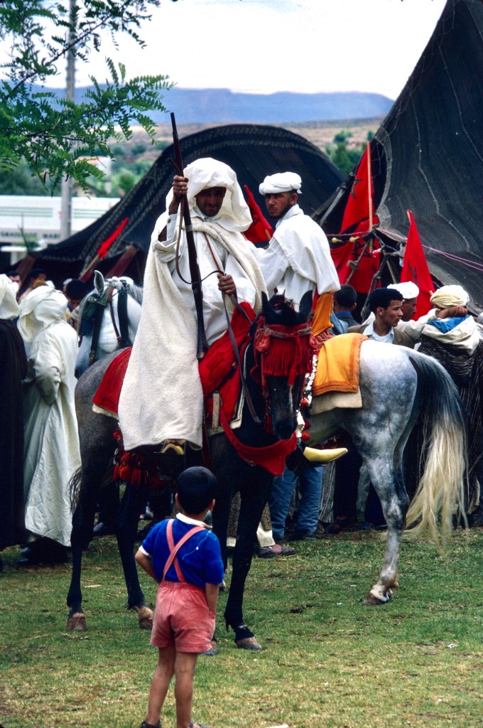
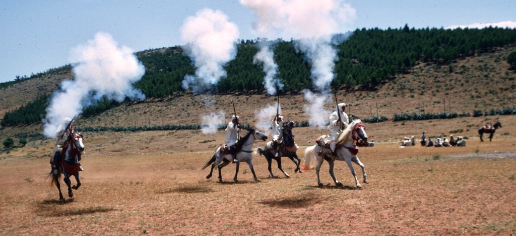
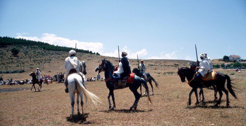
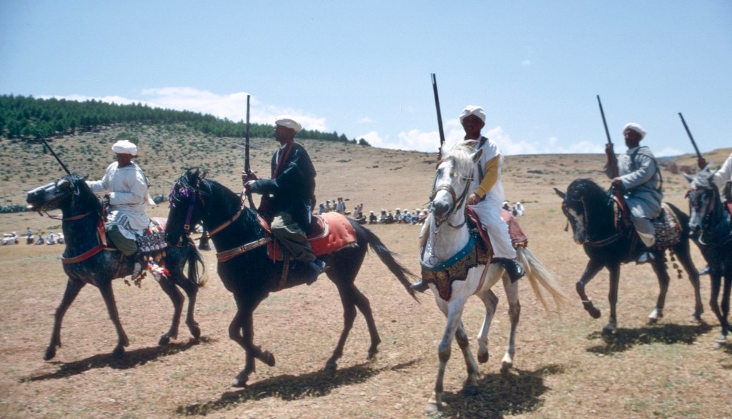
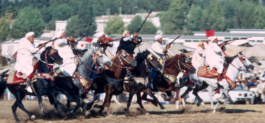
Traditionnellement le festival durait trois jours, mais je ne me souviens que d’une seule journée. L’année suivante, en 1969, je me trouvais peut-être ailleurs pendant le temps du festival. En 1970, j’y ai de nouveau assisté et cette année-là, il y a eu une fantasia, un spectacle traditionnel de jeux de poudre et d’équitation—le seul auquel j’ai assisté pendant mon séjour au Maroc. Enfin, le seul comportant des chevaux, car à Moulay Bouchta, un cortège d’hommes armé de vieux mousquets s’était rendu sur l’espace devant le sanctuaire et a offert un spectacle impressionnant.
Jeu de poudre devant le sanctuaire à Moulay Bouchta 1970
A la fête des cerises, les cavaliers alignaient leurs chevaux sur un terrain plat, les éperonnaient et galopaient le long du terrain en agitant leurs mousquets avant de tirer une salve en l’air.
L’un des cavaliers. Photo de Gaylord Barr. 1968On se prépare pour la course. 1970Chargement des mousquets 1970Les cavaliers des tribus berbères environnantes sont fiers de leur savoir-faire équestre et leur beaux chevaux. 1970
.
Au galop le long du le terrain. 1970Tirant leurs mousquets 1970Pour ensuite recharger tout en se regroupant. 1970Bon nombres des cavaliers étaient des hommes de tribu plus âgés et suffisamment riches pour s’offrir un beau cheval. 1970Il y a eu plusieurs courses le long du terrain. 1970Certaines courses comptaient plus de participants que d’autres. 1970Les participants s’apprêtant à tirer. 1970Déchargeant leurs mousquets au grand galop. 1970Et produisant toujours des nuages de poussière. 1970
Les photos de ce billet présentent la fête des cerises telle que je l’ai vécue, à la fois en tant que nouvel arrivant dans le pays et en tant que personne ayant vécu à Sefrou pendant quelques années. Les foires d’État et de comté sont courantes aux États-Unis et au Canada, partout où l’agriculture est importante, mais je n’ai jamais visité la foire du comté de Niagara à Lockport, dans l’État de New York, près de l’endroit où j’habite. Les foires, ce n’est vraiment pas mon truc, même si assister à l’exposition nationale canadienne a été un moment fort de mon enfance, parce que j’aimais les manèges et la nourriture.
Le festival des cerises a été très divertissant. En juin, il faisait toujours beau. La ville nouvelle était bondée, les animations étaient intéressantes et des amis de tout le Maroc venaient nous visiter. Ceci étant dit, bien des années plus tard, maintenant que je suis de nouveau chez moi, je ne me rends pas au festival de la pêche à Lewiston NY, à seulement 12 kilomètres de chez nous, ni au festival de l’éperlan de Lewiston, un événement beaucoup plus modeste célébrant le petit poisson savoureux qui remonte la rivière au printemps. Je trouve que les foires sont faites pour les jeunes, les exposants, les vendeurs et les marchands. Toutefois, le festival des cerises est désormais reconnu par l’UNESCO comme faisant partie du patrimoine national du Maroc. Si vous vous trouvez dans le nord du Maroc en juin, je vous encourage à y participer. Au minimum, vous aurez le plaisir de voir des foules de Marocains s’amuser. À l’époque où je restais au Maroc, la vie était difficile pour beaucoup et les fêtes nationales ou locales s’avéraient des occasions de célébrer avec des amis et avec la famille. Je m’imagine qu’à cet égard, rien n’a changé du tout.
Just recently, I was asked by a Moroccan reader of this blog, who wrote from Alberta, Canada, if I had photos that I could share of the Cherry Festival.
Now, Morocco, spectacular for its natural beauty, is also be a country of spectacles. For me, the Marrakesh Folk Festival comes to mind immediately, along with the various celebrations of holy men and religious fraternities although there are many other culture and sports events. Still, there are many smaller festivals that are less well-known. Among them, the Cherry Festival in Sefrou is the oldest, having been founded in 1920.
Sefrou, only 28 kilometers south of Fes, has one of the best known local festivals, La fête des cerises. This ancient city, very close to Fes, has traditionally been the last truly urban place south of Fes, on a road formerly known as the treq es-sultan, the king’s road. A major highway follows the old caravan route, crossing the Middle Atlas Mountains, descending onto the plains of the upper Moulouya River, and then rising again to cross the High Atlas Mountains to end in the Tafilelt, birthplace of the ruling Alouite dynasty, on the very edge of the Sahara. Today tourists travel that highway to reach the impressive sand dunes at Erfoud, and truckers carry their cargos of manufactures and dates and saffron to and from Fes, braving slippery snow-covered roads on the Middle Atlas plateaus.
This table d’orientation, a very French object, stood in the gardens of the Palais Jemaï hôtel high above the the city of Fes, and pointed out important landmarks to the south. A view from the Oued Agaï represents Sefrou, but after the flood of 1950, the city might have been better symbolized by its gardens—or cherries.
Once a home to a very large Jewish community, many Jewish tourists now visit the city since the establishment of diplomatic relations between Morocco and Israel. There are several websites dedicated to documenting the Jews of Sefrou, and the city itself dates back to the time of the founding of Fes or perhaps even earlier.
“A city buried in the trees.” Early postcard with a part of the Kelaa in left foreground.An early map of Sefrou shows almost all the city’s structures enclosed by the defensive wall. The French were developing the area outside the wall to the west for themselves. My house, inside the wall, had not yet been built and its site was a still a garden.
Not long after I moved to Sefrou in 1968, I attended Sefrou’s Cherry Festival for the first time. Gaylord Barr was already in Sefrou working at the Ministry of Agriculture CT (Centre des travaux agricoles). Jerry Esposito, who had been teaching English at the newly opened lycée, may have completed his service and already left the country by time of the festival in June. Carolis Deal and John Abel, who had started the primary school chicken coop that I took over, also had left.
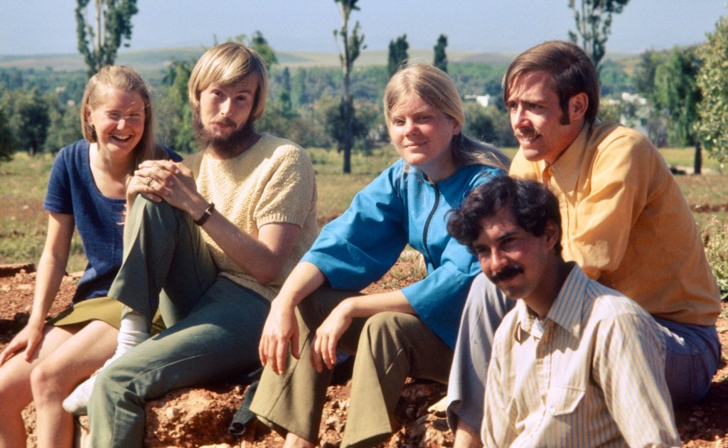
Gaylord Barr, Marc Miller, and Phil Morgan, all Morocco X volunteers. 1968
Several other volunteers showed up in Sefrou to attend that year: Phil Morgan, Marc Miller, and Steve Boeshar.
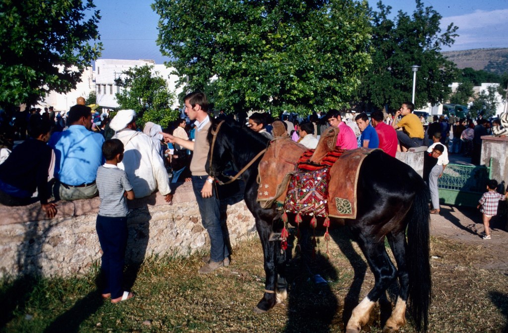
Sefrou’s proximity to Fes and easy access made the Cherry Festival a major regional attraction, and, with volunteers already living in Sefrou, accomodation was never a problem for the visitors.
Jan, Ruth, and Gaylord all taught English at the lycee. During the 1970 festival.
I knew little about the event, other than it featured cherries. Moroccans call cherries hab el-moulouk, which mean the love of kings, and the local variety, el-beldi, is reputed to be especially sweet and flavorful. Sefrou occupies a mountain depression at a high enough altitude for cherries to thrive, but the city had many other fruits and vegetables in the old gardens that surrounded it. In the orchards grew oranges, pomegranates, figs of more than one variety, and many olives trees. I really liked the local strawberries more than the cherries.
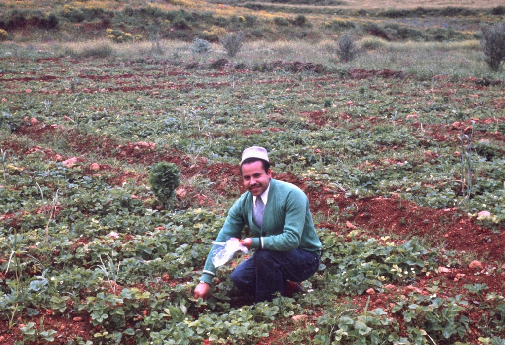
Picking strawberries in the spring. 1969This field was only a couple of minutes walk from the medina.Picking strawberries with Mohammed and Ali. Note the olive groves. 1970
The city population has more than doubled since I lived there, and the built-up area has spread far beyond the old city’s walls. The growth surprised Gaylord Barr who stopped in Sefrou on a trip home from Saudi Arabia in 1997. In my memory, the extra-muro areas, excluding the ville nouvelle, were mostly limited to the Derb el-Miter, Habouna and Seti Messaouda quarters. I make this digression into the demography and urbanization of Sefrou before the sprawl simply to underline how easy it used to be to walk out of the medina, and, within a few minutes, be in the gardens that surrounded the city. On Fridays women would walk in groups, small children in hand, to picnic in the orchards, eating fresh fruit, getting some fresh air, and, of course, gossiping over tea. I loved the proximity to the country and took frequent walks to the neighboring village of Bhahlil, famous for use as caves for dwellings.
A stroll to the gardens, along the wall of the old Jewish cemetery. 1969
People used to talk about Sefrou before the flood. I wonder if they now talk about Sefrou before the sprawl, the time when almost everyone, save the rich and powerful and foreigners, lived in and around the medina. The gardens and orchards of Sefrou characterized the city in those days, and sometimes travelers not unsurprisingly likened the city to an oasis.
A view looking southeast. The Jewish cemetery is located in the lower left of the photo. Sefrou occupies a bassin, with hills surrounding most of it. 1969
The term moussem has been used to describe the festival, but from what I can gather, the Cherry Festival, created around 1920, was celebrated more as an agricultural fair in the European or American sense. The word moussem often has the meaning of a religious pilgrimage to the tomb of a local saint, common in the Maghreb. There were several zawias, or religious brotherhoods, located in Sefrou, as well as a marabout and a few special places sacred to the locals, but I never witnessed a regional religious celebration on the scale one finds at Moulay Bouchta or Jbel Alam. The Cherry Festival appeared to be a uniquely secular event in a country where religion permeated daily life and most public ceremonies. The selection of a “Miss Cherry” and parading the young woman struck me as at odds with Muslim values.
There were, of course, the usual tented dining facilities for local dignitaries that one would find at any public Moroccan celebration as well as hawkers of wares, foods, sweets, and drinks. People from the medina and the countryside circulated in the ville nouvelle.
Women resting in the shade. 1968Strolling among the tents on the edge of the ville nouvelle. 1968A water carrier refills at a public tap. 1968Different generations regard each other. 1968Gaylord in a crowd of kids.……and chatting with a Berber horseman about his mount. 1968Amusement rides were a special treat outside major cities. 1968Along the main street of the ville nouvelle, people gathered to watch the parade. 1970 or 1973The main street on a more typical summer day. The hustle and bustle of city life was in and around the medina. The ville nouvelle spread up the slopes to the right. Perched at the very top was a French fort and military barracks and a marabout. 1969
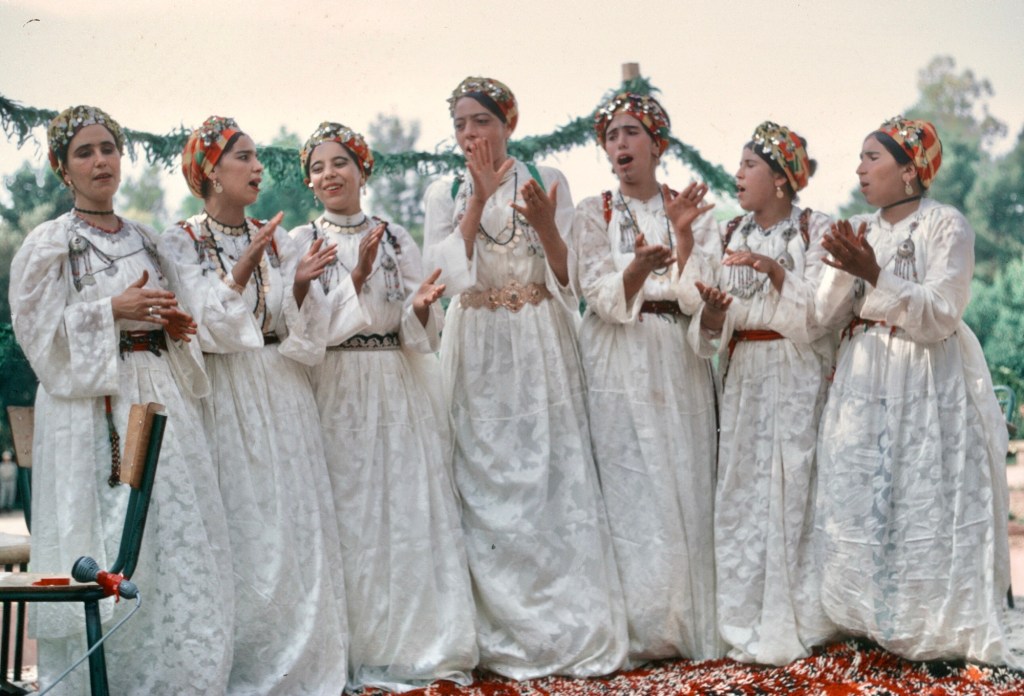
A jury of prominent locals selected a Miss Cherry, who was paraded down the main street of the ville nouvelle aboard a float. One of the floats that first year also featured dancers performing as they were carried along.
Professional dancers from the Middle Atlas. Dancing was only one of their professions according many Moroccans. Photo by Gaylord Barr. 1968The dancers with a musician, outside the tent of the notables. Photo by Gaylord Barr. 1968Dancing for the crowd. Photo by Gaylord Barr. 1968Spectators.
The parade included the public display of a woman quite unusual in a land where women covered themselves in public. The crowds along the main street of the ville nouvelle were curious.
The crowds along the parade route were dense and mostly women and children.The float of the Ministry of Agriculture.The poster on the float shows the benefits of modern plows.A water carrier offering drinks to the crowd.Miss Cherry. 1969 or 1970.Women and children sitting along the curb.
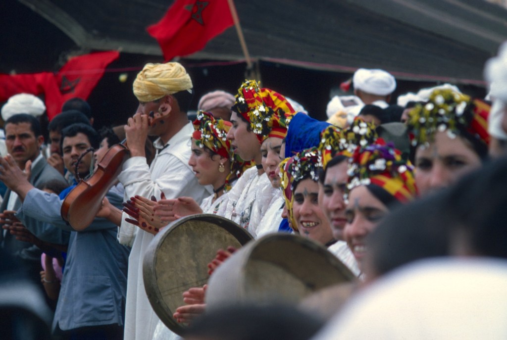
The festival did offer the opportunity for religious brotherhoods to perform, perhaps as entertainment for the spectators, but as serious ritual for the performers.
I have always referred to those I saw as Aissawa, which would have made them part of the Sufi brotherhood centered in Meknes. A large shrine with a mausoleum where the Sufi master lies, Ben Aissa, who is also referred to as shaykh el-kamal, the perfect leader, exists in Meknes. An important moussem takes place there every year on the day celebrated for the birth of the Prophet Mohammed, the Mouloud.
The courtyard before the sanctuary in Meknes on the Mouloud.Part of an Aissawa procession in Meknes.
In the first Cherry Festival that I attended, a group of Aissawa or, perhaps, Hamadsha, who ate fire and handled biting snakes, danced themselves into a trancelike state. A few of the photos show the wide-eyed faces of onlookers: these performances were far from the formal rituals of everyday Islam!
The men danced in a circle, chanting and beating their breasts. Photo by Gaylord Barr. 1968One of the musicians. Photo by Gaylord Barr. 1968The instruments were all traditional.Dancers would take turns performing in the center of the the circle. Most of these shots were on Kodak Ektachome film. The processor botched this one: the center of the image should not be pink. Today it is so simple to take photos and, with film no longer widely used, electronic cameras and cell phones can capture and store a truly enormous amount of pictures. I had either 20 or 36 pictures on a roll of film, the film was expensive, and its sensitivity was limited to bright conditions.Chanting and dancing. The amulets held religious writings.As the music continued……the dancing continued. The man on the right has snakes draped around his neck.Fire eating became part of the ritual. I love the looks on the spectators’s faces. They group began by asking the crowd for contributions or donations.Fire and snakes.The fire was real……and the snakes were certainly real. I could see blood oozing from the punctures of the snake bites.One could carry snakes and eat fire. The show was mesmerizing and, if I hadn’t been taking photos, my face might have shown as the same rapt attention as the faces of the spectators in these photos.
The festival traditionally lasted three days, though I only remember one day. The following year, 1969, I may have been away during the festival. In 1970, I once again attended. That year there was a fantasia, a traditional display of powder play and horsemanship—the only one that I ever witnessed while living in Morocco. Well, the only one with horses, because at Moulay Bouchta a procession armed with old muskets walked to the space before the shrine and put on an impressive display.
Powder play before the sanctuary of Moulay Bouchta.
At the Cherry Festival, the riders lined up their horses on flat ground, spurred on their steeds, and galloped down the field waving their muskets before firing salvos into the air,
One of the riders. Photo by Gaylord Barr. 1968Getting ready for the ride.Loading muskets.Getting ready.Galloping down the field.Firing their muskets.And then reloading while regrouping.Many of the riders were older tribesmen, wealthy enough to keep a beautiful horse.There were several runs up and down the field.Some charges had more participants than others.Getting ready to fire.Discharging their muskets at full gallop.And always producing clouds of dust.
The photos in this blog piece present the Cherry Festival as I saw it, both as a newcomer to the country, and then as one who had lived in Sefrou for a couple of years. State and county fairs are common in the US and Canada, wherever agriculture is important, but I have never visited the Niagara County Fair, in Lockport, NY, close to where I live. Fairs are not for me, though attendance at the Canadian National Exposition in Toronto, Ontario, was a highlight of my childhood because I loved the amusement rides of the midway and the foods.
The Cherry Festival was great fun. In June the weather was always fine. The ville nouvelle was crowded. The entertainment was interesting. And friends visited from all over the country. That said, years later, at now home again, I do not go to the Peach Festival in Lewiston, NY, just 12 kilometers away, nor to Lewiston’s Smelt Festival, a much smaller affair celebrating a small but tasty fish that runs up river in the spring. I think that fairs are for the young, the exhibitors, and vendors and merchants. But the Cherry Festival is now recognized by UNESCO as a part of the national heritage of Morocco. If you happen to be in northern Morocco in June, you should think of attending. At the very least, you will have the pleasure of seeing crowds of Moroccans enjoying themselves. When I lived in Morocco, life was difficult for many and holidays were opportunities to celebrate with friends and family. I imagine that in that respect nothing has changed at all.
My home in Sefrou was about 30 kilometers from my workplace in Fes. I liked the fresh air and small town atmosphere of Sefrou and I was fortunate that I could live there. The downside was that life in Sefrou required that I take a shared taxi or local bus to Fes every morning.
The bus stop and grand taxi stand, opposite the Bab Mkam, Sefrou. 1969.
Once one clears the edge of the depression in which Sefrou lies, the road descends to the rich agricultural plains of the Saïs. The ride wasn’t a long one, but it soon became a routine, and I needed a way to pass the time. I read books.
After harvest, Sefrou-Fes Road. 1969.
One of most memorable was Mikhaïl Bulgakov’s novel, The Master and the Margarita. Bulgakov died in 1940 and his novel was only published in the late 1960s.
The first edition of The Master and the Margarita.
The copy I read must have been the earliest English language translation, and how I came by it, I can’t say, though Peace Corps volunteers often passed on their books to others once they had finished them and I most likely got it from another volunteer.
Today there are many translations of the novel, several in English alone, and Bulgakov’s work is highly regarded as one of the few novels of quality written during the Soviet era. That said, it is not widely read. Many Americans do not like Russian novels because they are often long, and filled with difficult to pronounce Russian names, with patronymics, diminutives, and nicknames. In Dostoyevsky’s novel “The Idiot,” the character Prince Myshkin is referred to by his full name is Lev Nikolayevich Myshkin, his patronymic, Lev Nikolayevich (using his father’s name, Nikolai), his diminutive Myshkin (a shortened, informal form of his last name), his nickname, the Idiot (a derogatory term used by some characters in the novel), and his formal title, Prince Myshkin. These variations do highlight the cultural and social nuances attendant with their use, and the author used them for that purpose.
The Master and the Margarita long and complex structure may also deter some readers. There are three intertwined plots: one centers on a writer driven insane by the havoc wreaked by Satan when he appears in 1930s Moscow, another on Pontius Pilate, with a realistic, but different, depiction of the judgement and death of Jesus, and the last, on a love story of a woman who would sell her soul for the man she loved, a novelist struggling with writer’s block.
The novel satirizes life under Soviet communism. Before he wrote it, Bulgakov had been a successful playwright, and it is said that Stalin attended one of his plays 15 times! Perhaps this is why Bulgakov survived the purges of 1930s. The secret police seem to have known that he was writing an unflattering account of the system.
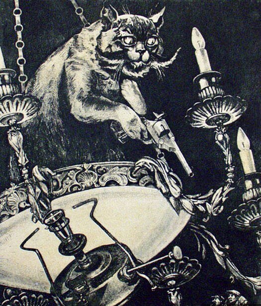
Behemoth the Cat
The novel mixes stark realism with fantasy and satire, sometimes in startling ways and sometimes in broadly comic ones. One can read it quickly to pass time as I did then or one can spend a lifetime examining the connections between the characters and plots and speculating on what Bulgakov is really saying. Much in the novel is not as it really seems, which should be taken for granted in a novel where one character is a huge, black, chess-playing cat, who talks, walks on his hind legs, and packs a pistol.
Behemoth shoots it out with the NKVD agents. Courtesy of WikiCommons.
Just recently there have been newspaper articles about a film version of the novel now playing on Russian theaters. The film has become a big hit there, and those commenting on it are quick to speculate on whether (or when) the censors will remove it. Authoritarian hypocrisy and toadyism aren’t limited to the communists.
There’s no better time to read Bulgakov. While many in America make their own Faustian deals in advance of the national election, others look forward to the arrival of Easter with its promise of redemption and new life.
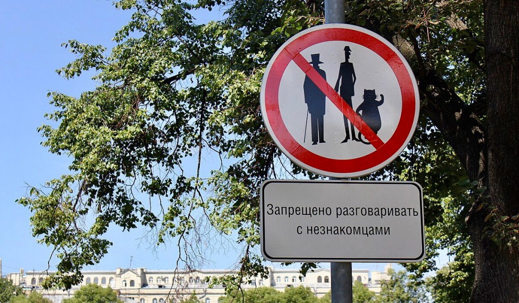
The Master and the Margarita begins in Moscow at Patriarch Ponds where a mysterious foreigner joins a conversation. Today this sign warns “Forbidden to talk with strangers.” Photo by Dima. WikiCommons.
Since the early days of Peace Corps in Morocco, many things have changed. I’ve said that before and I will no doubt say it again as long as I write here. As a senior citizen I do not take change for granted.
One development that has fascinated me, perhaps because many years ago I took college courses in geology, is Morocco’s increasing prominence in the world of paleontology stemming from frequent fossil discoveries that date from the time of the dinosaurs.
When the supercontinent Pangea could no longer abide by itself and decided to break up about 200 million years ago, North America and North Africa went their own ways and each got custody of some of their dinosaur children. Those children, separated by waters too deep to swim, evolved differently, and that is the interesting point of a recent article in The Conversation. The North American branch of the tyrannosaur family sports numerous fossil remains of T-Rexes from Montana, Alberta, and North Dakota, enough for some to have been sold to private collectors. Fossils of their North African relatives are rarer and are different in significant ways.
An abelisaur, a cousin of the tyrannosaurs, from a fossil found in Khouribga Province. Pencil and graphite on paper with additional digital editing, all by Nick Longrich. WikiCommons
Much of Africa consists of high plateaus, mountains, and deserts. Until recently, Europeans knew little about Africa’s interior because rapids and waterfalls rendered the continent’s great rivers unnavigable for large craft. Volcanism, erosion, and rising sea levels have left Africa with relatively few areas where the fossil record is long and well-preserved. Fortunately, Morocco has been well endowed with fossil deposits where, in recent years, paleontologists have made numerous important discoveries.
Today some tourism companies tout fossil as souvenirs of Morocco, and I would never begrudge poor Moroccans for selling fossils. Just the same, I think that preservation of the country’s most important fossil beds as important cultural heritages, much as Canada has protected the Burgess Shale in the Canadian Rockies and Britain its Jurassic Coast, should be incumbent upon the government of Morocco.
The eastern folded zone of the Middle Atlas Mountains. Early morning on the road to Taffert. The rock strata are mostly Jurassic limestones. 1969
I did not return from Morocco with any rare fossils, but I do remember, when rambling about Jbel Bouiblane, that the gullies carved in the the mountainsides by melting winter snows did contain many fossils. In May 1969, on the outing described elsewhere on this blog, John Paulas found a large ammonite and had to be pulled away from the stream bed where he stumbled upon it so we could continue our way.
The ammonites had coiled shells varying from a few millimeters to over two meters wide. All ammonites were predators as are their modern cephalopod relatives, squid, octopuses, and chambered nautiloids. Though relatively common, overfishing and habitat destruction menaces the latter as well as almost all living things in the ocean today.
The Whitby coat of arms and its “serpentstones.” Courtesy of WikiCommons.
Interestingly, in medieval Europe, ammonite fossils were often called “snakestones” or “serpentstones” and thought to have religious origins or curative powers. They constitute a common fossil on southwest England’s Jurassic Coast as well as on the Dinosaur Coast, near Whitby in North Yorkshire, England, where Captain Cook learned his seamanship and Dracula’s ship washed ashore. Whitby’s coat of arms features “snakestones.”
When I began this blog, I used old color slides from the nineteen sixties as prompts for much of my commentary. I thought many of the photos that I took were interesting enough to share widely and some represented parts of my Peace Corps experience very well. Although I still have many slides from Morocco, I left off digitizing them a couple of years ago. Needing writing prompts, I have for some time looked to old documents, artifacts, and the media, but I haven’t posted nearly as often. Now, occasionally, an old memory or something that I wrote here earlier prompts me to write.
In the case of this post, I previously referenced the film Before Sunrise. The young protagonists of that film, French and American, meet on a train. The young man convinces the girl, who is on her way home to Paris, to stop off with him in Vienna where they spend the night walking and talking. He will fly home to the States in the morning, and she will resume her journey to France.
A poster for Under the Skin of Night, written and directed by Fereydun Gole, which features a picture of the Iranian protagonist, portrayed by Morteza Aghili.
After I had written the post, another movie with a nighttime setting came to mind and made me think of Morocco. I watched the second film, Under the Skin of Night, (zir-e poost-e shab), in a theater in Tehran, Iran, in July 1974. Though my command of Farsi was poor, the dialogue was minimal and the action made most of the movie clear.
Julie Delpy and Ethan Hawke, on the streets of Vienna, in a still from Before Sunrise.
The theme of both films involves young people who meet by chance and decide to spend the night together. In Before Sunrise, the protagonists are privileged and wealthy enough to afford foreign travel, and self-discovery is not a luxury, just a part of growing up. They fall in love, even propose a future meeting in six months, to test the strength of their feelings. Their meanderings on a summer’s night in Vienna are filmed in color and involve no hardships.
A street scene in central Tehran. 1974. Much of the movie takes place farther north, in a more modern neighborhood.
Zir-e poost-e shab has a different story altogether, and begins, with a scarab beetle rolling a ball of dung. A young American tourist in Tehran spies a petty thief in the act stealing hubcaps, and her complicity creates a bond. The two do not search for meaning in life, neither speaks the other’s language, but, much more basically, for a place to have sex. For the girl, the sex will be casual. She, too, will catch a flight home in the morning. For the man, the night is the chance of his life to bed down with a foreigner, and perhaps even steal a new life from fate. But only one of this pair is privileged: the other lives from day to day on the edge of society.
Filmed in black and white, the story centers on a long, tiring, and ultimately fruitless search for a place where the two can be alone. He has no money. Living on the street, the man’s class and poverty work against his chances. Central Tehran is cold and unwelcoming. He takes the girl to Shemiran, a wealthy northern suburb that more closely resembled Beverly Hills than the rest of Tehran. The girl swims topless in the pool of a rich estate where his father was employed as a gardener, while the man is beaten up and thrown into the street. He ends the night in jail. There is no future to his relationship with the girl. They will never meet again.
I worked in Fes, a prime tourist destination, easily reached by bus or train from other major Moroccan centers. My office was in a government building in the Ville Nouvelle. As I lived twenty miles away in Sefrou and could not go home for lunch, I spent many hours in cafes, eating tuna-filled baguettes and nursing Cokes, often cut with a local sparkling water, Oulmès.
I often ate lunch at the Zanzibar. The C.T.M. bus station was just up the street.
Young foreigners frequently visited Fes during the tourist season, and I often watched as equally young Moroccan hustlers worked to pick up tourists with offers promising authentic tours. Morocco was a place of unemployment and underemployment with a young and rapidly growing population. I once asked a shoemaker in Chauen if he’d ever been in the army. He replied laughing, “Yes, of course, in the army of the sitting”, a common reference in Arabic for the unemployed. Without family support or connections, neither an education nor a job came easily.
Tourists were easy marks, especially those without good French, and the medina, the old city, was a maze of winding streets and alleys, not at all easy to navigate, a place where a guide was useful. The would-be guide could sell his services, collect commissions from the shopkeepers selling tourists everything from cheap souvenirs to expensive rugs, and sometimes offer nighttime accomodation, with sex always a possibility for the older and most charming. Sex for most young Moroccan men in those days virtually always involved prostitutes. No other women were available.
As for the foreigner, sex with a native might make an exotic souvenir for some. The sixties in the developed world were a period of experimentation with drugs and sexual liberation. Young people traveled the world as if they were still at home, and, being far from the eyes of their families, had even fewer social constraints abroad.
Moroccan street people were happy to oblige them. However, Moroccans (and Mediterranean men in general) looked down on the sexual mores of young western women and many found it hard to distinguish the sexual freedom of foreigners from that of local prostitutes. In those days, young women were seldom available for young men except through prostitution. The freedom of western women was incomprehensible. I heard this opinion often in North Africa, and once even here in North America.
I remember a night in Montreal, when a college friend and myself arrived to pick up our dates, two nurses. They shared an apartment and when we arrived, there were two Lebanese guys about to leave. Unaware that my buddy had grown up in Beirut and spoke an Arabic dialect, they talked freely with each other, disdainfully referring to the two women as prostitutes. I think that they had dropped by thinking the women had no plans that night and were disappointed. When Steve, addressed them in fluent Lebanese Arabic, they were taken aback. For us, their comments took some luster off the dates.
Moroccan hustlers did not target resident foreigners who usually kept to their own social circles. Volunteers usually dated other volunteers, consular personnel, French coopérants, or had girlfriends back in the States. A few volunteers that I knew did visit (or were visited by) local prostitutes, especially in Middle Atlas towns or in big cities.
Volunteers and coopérants were a privileged group. Though watched by the police and neighborhood informants, they were almost never arrested or prosecuted, and occasional, perhaps even habitual, bad behavior was overlooked. They were short-term guests of the government.
I cringed a bit as I observed the hustlers at work. They preyed on the naive and those avid for “authentic” experiences. Years later, as I look back, I am a bit less judgmental about their behavior. The influx of country folk had already turned much of Fes’s medina into a slum. Morocco’s population was growing quickly and a large segment of the population was under 21. Young Moroccans earned their money as they could, found sex where they could, while privileged foreign youth pursued pleasure and excitement, sometimes with an insouciance that astounded me. Caveat emptor.
The final scene of Under the skin of night is both powerful, sad, and as symbolic as the Sisyphean task of the scarab. Escaping class and poverty, in societies where great inequalities exist, is nearly impossible for most. A young Moroccan’s best chances for a good life often lay abroad or depended on foreigners.
As a footnote, the movie, Under the skin of night, though well regarded, seems to be difficult to find, but there is a poor copy, with limited English subtitles, on YouTube.
During the nineteen sixties, amid the turmoil and turbulence of an unpopular foreign war, a bitter struggle for civil rights, and a generational revolution, American university students discovered a British work of literature that had appeared in the 1950s without much critical acclaim in America.
When the Barbara Remington, the illustrator of the Ballantine paperback edition, passed away, the New York Times published her obituary. In it, the newspaper reporter, Julia Carmel revealed that Remington had created the paperback covers without having read the books, pressed by time and inability to find available copies. “I didn’t know what they were about,” she later admitted. “I had sketchy information at best.” 2/17/2020, NYT.
Ballantine Books published the three paperback volumes of The Lord of the Rings trilogy with funky cover illustrations and a plea by the author for readers to buy only authorized versions of his work. Soon slogans such as “Frodo lives!” began appearing here and there to the mystification of those who had never heard of Tolkien, let alone Frodo.
I don’t remember if the Rings trilogy was included in the book lockers distributed in the early days of the Peace Corps, but there were certainly lots of copies circulating among volunteers.
I read the book for the first time in 1966 in a Canadian National Pullman car, somewhere between Vancouver and Toronto, while miles of mountains, prairies, and pine forests slid by my window. Everyone my age seemed to be reading it. Tolkien had created a fantasy world where one could lose oneself in an epic adventure, one replete with drama, action, and suspense. The Lord of the Rings relieved the tedium of travel and filled the day. The prairies and the boreal forests of Canada are beautiful, but they sometimes seem to go on forever, and are enjoyed best in glances.
Late afternoon and still a long walk ahead to the market in Sefrou. El Menzel and the massif of Bouiblane in the distance. 1969.
I reread the trilogy again, a few years later as I traveled from Algeciras to Catalonia, on much less comfortable trains, and by bus into Andorra and France. Leaving Spain, Catalonia’s rugged mountain scenery provided a dramatic backdrop for the Concerto de Aranjuez playing through the vehicle’s overhead speakers. The trilogy made a wonderful travel companion, and seemed to fit in perfectly.
In 1967, training for Peace Corps service in Morocco in California, I had tried to imagine the new and exotic world to which I would soon travel. Having had a Moroccan friend who lived in the dorm room across from my own in my senior year in college, I was better informed than most of those in my group. Still, what I find today, looking back at the imagination of my youth, was something resembling Middle Earth.
Typical thatched houses of the pre-Rif. 1969
There were no battles between good and evil, but Morocco was a land where the US kept secret military bases, and the Cold War was never far off. There were no imaginary creatures, but there were jinns and ghouls, no Shire except for douars dug into mountainsides, no elves and dwarves, but many forests and caverns where they would have made their homes.
Descending into one of Taza’s deep caverns, Friuoato. The sink hole where one enters is 400 feet deep, with a 100 foot opening to the sky. The French added iron stairs bolted into the walls, which were in serious disrepair in 1970. The cave is closed today for safety reasons. A passage at the bottom gave access to a series of rooms.
There was no panoply of races and creatures, but there were Arabs and Berbers and Jews and those curious peoples from Europe, the French and the Spanish. There was no quest for us, just a two year stint of service, no fellowship except that of other volunteers, staff, and the Moroccans who befriended us, no band of hobbits, just 40 young Americans dropped into rural locations.
Fantasia in Sefrou. 1970.
There was, of course, a history to the place extending back to antiquity, armed men on horseback, African animals, new foods, expansive views, walled cities and veiled women, palace intrigue, secret police, and coup attempts.
Morocco was a land where oleanders bloomed all summer in dried up water courses, and black tents surrounded cold, clean lakes that had no visible sources.
Late afternoon at Daya Iffer, a karst lake and Berber tents in summer pasture, south of Sefrou. 1968
Goats climbed trees, porters worked themselves to death for a few dirhams a day, and some Moroccans lived in caves.
Troglodyte houses in Bhalil. 1970
Morocco seemed old and timeless to our innocent eyes, both sadly poor and richly exotic. Moroccans in 1968 yearned for a brighter future, but were still shackled to the past.
Independence had brought pride and hope as they began to learn to live without the French and Spanish, but the real issue then was how Moroccans would live with each other once the foreigners had left.
The population was young, growing, and optimistic .Sefrou. 1969
None of our group died there, though at least a number of us came close. We willingly gave up many creature comforts as we worked in rural areas. Many of us lived without heat, hot water, and sit down toilets.
We finished our mission, as well as we could, before sailing off into the West on the wings of a Pan Am Boeing 707, “un Boeing bleu de mer” as Robert Charlevoix has described one. There we resumed our lives, continued our education, took jobs, married and had children, no longer worrying as much the war in Southeast Asia. Most of us had won the draft lottery or were fortunate to have local selective service boards that believed that we, though non-combatants, had served our country. Some of us even returned to Morocco and spent more time.
Middle Earth did not survive the wars and conflicts that finally led to the destruction of the one Ring. Change was in the air long before the trilogy’s protagonists set off for the Western Isles. And change was in the air in Morocco, too, even as we left.
Migrant workers were beginning to settle their families in Europe, rather than leaving them in Morocco and returning to them every summer as was customary. The population was growing rapidly and sprawling urbanization along with it. Cheap travel was bringing more and more foreign tourists. The revolution in transistors that led to the computer had just begun and eventually would provide much easier communications than the local PTT or rate hanout with a phone. Moroccan Jews as well as foreigners were leaving the country as the new Moroccan elites tightened their hold on the reins of power and began to enjoy the spoils of independence.
We never suspected that Berber would gain official recognition as a national language, and, more radical still, an attempt would even be made to write darija, the Arabic dialect almost everyone spoke, but never wrote. The colonial tongues would come under increasing pressure to the new international language, English, the language, of course, that many of us were teaching. Argan oil went from a prized element of Swasa cuisine to a Western cosmetic fad.
In an argan grove near Taroudant. The goats ate the leaves and fruit, and excreted the argan nuts which were then collected from the ground and pressed for their oil. 1973
Today, PCVs in Moroccan still write home about the exotic, the romantic, and the quaint, just as we did, but now they do it on blogs. Cellphones and computers connect many of them in real-time with their friends and families back home. Many Moroccan students have now gone to the US for their studies. Moroccan restaurants are found in all the major America cities.
Morocco has established diplomatic relations with Israel, and Moroccan Jews and their descendants now return to Morocco as tourists.The populations of major urban centers have swelled and old provinces have been divided and subdivided into many newer ones.
Anthropologists, archeologists, and paleontologists make new discoveries daily that change the story of human prehistory as well as that of life from times far before humans walked the earth. Religious fundamentalism, not longer an artifact of the past, has become an active social force, not only in Morocco, but, to the amazement of some of us, in our native land.
I prefer to remember Morocco as a quiet postcolonial place, awaking after a long nap, refreshed and energized by independence and eager for a hopeful future. Was it a better time? Were problems more manageable then? The French poet and songwriter Georges Brassens who has written many songs about the passage of of time, reminds us that Time is a disquieting god, “un dieu fort inquiétant,” killing time in his own ways. Time blurs the memory and softens the hard edges of the past. For some of us Morocco still may seem the garden of the golden apples, but we should know better. We were guests, not true residents.
And though our Morocco, a Morocco that was, has given way to a newer age just as Middle Earth did, memories of its many enchantments still remain alive for us.
Today, as I read my alumni magazines, I reflect on Peace Corps times, when I had recently graduated and when the members of earlier graduating classes seemed so ancient. Now the alumni of those classes are long gone and my generation has assumed their place. Another voyage to the West approaches, an inevitable journey that require no special conveyance, just a divorce between my body and my soul, a metaphor I proudly steal from Brassens. He would approve, I am sure.
Anyone who has taken the A10 road from Marrakesh to Taroudant—and many tourists and Peace Corps volunteers have made this journey—has passed the Almohad mosque at Tinmel.
The mosque at Tinmel sits atop a prominence overlooking the valley. 1973
Filled with religious passion, the Berber tribes of this region swept out of their mountain fastness in the twelfth century and quickly conquered the empire of their predecessors, the Almoravids, extending their own control to most of Muslim Spain. Ibn Tumart, the dynasty’s founder, has been compared to St Bernard, founder of the Cistercian order of Catholicism. Puritanical, the Almohads ruled strictly, but as they settled down into urban centers, their own dynasty slowly was transformed by the cyclical process described by Ibn Khaldun, whose writings are precursors to modern historical and sociological inquiry.
The mosque at Tinmel in 1973.
During the time of their rule, the Almohads built three great minarets, the Koutoubia in Marrakesh, the Tour Hassan in Rabat, and the Giralda in Sevilla. These structures manifest grandeur, not only by their size, but by their simple but harmonious decoration.
The Almohads have left many monuments across North Africa and Spain, but the one that spoke to me most eloquently was the mosque at Tinmel. Human in scale, simple yet elegant in decoration, the mosque overlooked the birthplace of the dynasty, and was in the distant past a place of pilgrimage.
The mihrab, indicating the direction of Mecca. 1973
Although both the French and the Moroccans put some effort into its restoration, the mosque at Tinmel, just 6 kilometers from the epicenter of Morocco’s recent earthquake, did not survive. A thousand years of art and history perished in a moment.
The village at Tinmel as it was in 1973.
Still, bemoaning the loss of this monument should not obscure the human loss of the most recent tragedy to befall Morocco. There was a village at Tinmel and my deepest sympathy goes out to the villagers of Tinmel as well as all the others of the region.
I have written elsewhere in this blog, and at more length, about Almohad monuments, and I beg the reader’s indulgence for the brief repetition. Morocco has a special place in my heart and the recent tragedy is truly heartfelt.
If you would like to know more about Tinmel, here is a link to a recent article from The Conversation, and an article from the New Yotk Times on the Tizi n’Test road.
I have had this post in my drafts box for months. Some of the observations are trite, but they continue to have a special place in my memory. In view of the massive earthquake just suffered by Moroccans, I publish it because many of us did experience a quake in Morocco.
In Before Sunrise, two young people traveling on Eurail passes meet. The young man, an American student, convinces the girl who is on her way home to France, to get off the train with him in Vienna. He will be leaving in the morning for the US. They spend the night walking and talking and finally agree that they will meet again in six months. If you desire to know what happens next, watch the movie and its two sequels, but be advised that these movies by director Richard Linklater have much talk and little action. Not everyone enjoys that genre. I do. One of my favorite French directors is Eric Rohmer. In the Rohmer movie, The Green Ray, a girl can’t decide what to do on her summer vacation. Her story is a small slice of life, with boredom and indecision creating or replacing the drama.
The nights that I write about here occurred by chance, where serendipity and stupidity often fight it out. As for my serendipitous experiences, they usually lay somewhere on a continuum ranging from the innocuous to the dangerous. Sometime I found myself in places where I shouldn’t have been. In one’s youth, the line between the carefree and the careless is thin and often crossed.
My nighttimes abroad were more prosaic than those of Linklater’s protagonists. Still some gave rise to experiences that years later I still remember vividly, though committing old memories to print encourages remembrance and rumination and perhaps some inadvertent invention. Most of the experiences here are already described or briefly alluded to in other posts, but I mention them again with more elaboration.
On the last day of February in 1969, not very long after I had fallen asleep, I was wakened by a loud, roaring noise as my house in the Sefrou medina trembled. Turning on the lights, I could see that the bulbs that hung on long cords from the ceiling were swaying like pendulums. A great commotion had arisen in the street, and, outside the city wall, in the new areas of the neighborhood, there were sounds of people and vehicles where silence usually prevailed late in the night. Half asleep, an earthquake had awakened me. By the time I was fully conscious, I decided that the quake was over and I returned to a sound sleep. My neighbors, however, were terrified and many stayed out all night.
When the quake began, people naturally fled their houses for the wider streets outside the medina, and, if they had a car or truck, drove it into open areas where they would be safe from falling debris. The panic was understandable: in 1960, an earthquake destroyed the Moroccan city of Agadir, and killed 12-15,000 people in a matter of seconds.
That night in Sefrou there were no important aftershocks and most people gradually retreated into their homes rather than freeze in the cold night air.
The quake originated just to the west of the Strait of Gibraltar, where the African and Eurasian tectonic plates meet. At 7.8 on the Richter scale, the earthquake was felt widely in Morocco. With an intensity of VII on the Mercali scale, the quake was the strongest to hit Portugal since the Great Quake of 1755.
The Lisbon earthquake of 1755 destroyed the great unfinished mosque in Rabat. Commissioned by the third Almohad caliph in the 12th century, work ceased upon his death. The unfinished minaret, known as the Tour Hassan, was to be the tallest in the world. The summit is reached by an interior ramp large enough for a horse to be ridden to the top. Iron in the weathered limestone gives the Tour Hassan its distinctive color. Today a fence encloses the open area at the top, part of an effort to prevent accidents and suicides. When I first visited it with my Peace Corps buddies in January, 1968, there was no fence and one could literally dangle one’s legs off the side while taking in the magnificent views. Incidentally there was no fence around the American embassy either. It was a different world. 1968No fence, just a 50 meter drop. But what a view! Sale is across the river in the background and one of the river jetties just visible on the top left of the photo. The view of the casbah of the Oudayas, pictured elsewhere in this blog, is stunning, Marc Miller and Gaylord Barr. Rabat, Morocco. 1968
In the 1969, 11 Moroccans died and there was widespread minor structural damage, but the quake spared Sefrou. In Fes, I remember a volunteer’s house in Fes El Jedid that had a crack that extended more than two stories. Strangely, I don’t remember many volunteers talking about the quake, but I do remember a Peace Corps administrator and former volunteer, Don Brown recounting that he and his old Peace Corps volunteer housemate in Oujda were imbibing a late night glass of wine in Don’s Rabat apartment when they felt the shock. I emailed Don about it the other day and this is how he remembered the occasion.
Yes, it is true. PJ and I were on at least the second bottle of Boulaouane when the earthquake happened. As I recall, it happened about 2 in the morning, and like almost everyone else, we got out of the apartment building and roamed the street until the sun came up. We may have had breakfast at the Jour et Nuit.
— Don Brown, RPCV, Peace Corps Administrator, and Agricultural Development Consultant
The modern apartment building where Don lived was adjacent to the Peace Corps office and neither was damaged. For those of you who remember her, Emelina de Ros, the Peace Corps secretary, lived in the same building.
The Peace Corps office in 1968. Don’s apartment building is behind it on the right.
The quake left some Moroccan roads in bad shape. Even without a quake, the winter rains and thin soils often produced mudslides. Combined with the earthquake, many mountain roads were in very poor condition in March 1969, particularly those in the Rif region.
Despite the makeshift repairs, this bus got stuck where the hill subsided. I’m with some of my Ministry of Agriculture colleagues. I can’t forget the day I took this photo. One of them explained to me his theory of agricultural extension, “Mr. Brooks, you Americans really know what you’re doing in Vietnam. Bombs are the only things these peasants understand.” While extension was difficult, I didn’t share his belief that farmers could be bombed into modernity or that those in power always knew best. 1969.
In the fall of 1968 I had moved into the Sefrou medina with another volunteer, Gaylord Barr, who had brought an 8mm movie camera to Morocco, but soon found 8mm film expensive and, lacking a projector, he could not even watch his films. I had brought a 35mm SLR along to Morocco and was taking photos and slides like mad. That convinced Gay that a 35mm camera was what he needed and I offered to help him pick one out. Photo gear was expensive in Morocco, but we knew that Ceuta, the nearest of the two Spanish enclaves on the Moroccan coast, just opposite Gibraltar, had duty-free shopping. We chose a long weekend to go there and decided that we would try to hitchhike rather than take a bus. Morocco was well served by the national bus line, the CTM, and smaller companies provided good service to more remote areas. Volunteers seldom hitchhiked. That said, for whatever reason, we decided to hitchhike from Fes to Tetuan where we could get a local bus to Ceuta. Perhaps we had missed the last bus of the day from Fes.
Gaylord and I must have got on the road late, because I have no memory of anything but a high speed nighttime drive on rough, damaged roads. The trip was through still unfamiliar territory on a dark, rainy night to boot. The driver was headed all the way to Tetuan and was kind to stop for us. All he wanted was some company.
Waiting in the old Tetuan bus station for a bus to Ceuta. Early morning in March, 1969.
The road from Fes north winds through the relatively hilly country of the pre-Rif, then barrels down mountain valleys between Chauen and Tetuan. As I worked for the Ministry of Agriculture in Fes, I became familiar with the southern part of the route. The Province of Fes then stretched from the pre-Rif to the Upper Moulouya. Later, living in Chauen, I got to know the northern part as well. It was in the north that the Spanish dictator, Franco, then an officer in the Spanish army, participated in a disastrous retreat from Chauen during the Rif War, one in which thousands of Spanish soldiers lost their lives.
Today the entire route takes about five hours, but negotiating rock falls and mudslides probably slowed us down. The driver might have been drinking. He was certainly driving fast under the trying weather and road conditions. The night turned out to be a long one. We got to Tetuan early in the morning safe and sound, but the experience had been somewhat harrowing. That ended my hitchhiking experiences in Morocco, save on the road between Fes and Sefrou, when missing the last bus or grand taxi after work sometimes forced me to stick out my thumb.
Morning in Ceuta. 1969.
As a footnote, that trip was the first of many to Ceuta. Si Kamir, the director of the Sefrou Centre de Travaux where Gaylord worked, had been impressed by Gaylord’s slides, and asked him to buy an inexpensive projector. We made a special trip for that. It was a tiny, manual Olympus model with a bright lamp and a short throw lens, which proved perfect for slide shows on the walls of the house. I loved it and we had it for a very long time until Si Kamir finally asked for it. He had paid for it after all! In this age of digital photography and cellphones, it may be hard to imagine a time when cameras needed film which then had to be mailed to France for development, and when slide projectors, rare and expensive, were needed to appreciate one’s slides.
The next nighttime adventure happened on the road between Fes and Taza. The eastern Middle Atlas and adjacent Rif mountains are predominately limestone, and caves are plentiful. On one occasion, I went spelunking in a big cave south of Taza with a couple of Peace Corps architects who worked in Fes. I neglected to note that Jeep’s alternator light was red, and, on the way home, we ran out of battery power half way between Taza and Fes at three in the morning. The battery had completely discharged. With a defective alternator, we couldn’t even push start the vehicle. One of the architects hitched a ride into Fes, 45 km distant, found a tow truck, and came back with it. Remarkably, the tow cost virtually nothing. I should add here, for younger readers, that there were no cell phones and even regular telephone conversation was difficult in those days as few residences or small businesses had them. Often a volunteer needed to go to a PTT and use the post office’s booths. In any case, luckily for us, the road from Taza to Fes was a main east-west highway, and there was alway traffic, even in the middle of the night.
If you’ve read other articles in this blog, you already know about me being stuck in mud with swiftly flowing water pouring over a dip in the Tangier coastal road. In a driving rain, late at night, I knew my battery wouldn’t charge, and that I couldn’t afford to be stuck. Nevertheless, I struck out from Chauen for Tangier, in typical wet winter weather, and took the far less traveled coastal road between Tetuan and Tangier. Sure enough, as I came over a rise and into the dip, my car got mired in mud where water was pouring over the asphalt. The engine stalled and I couldn’t restart it, of course. The countryside was pitch black. I opened the driver’s side door to find water up to the sill of my often unreliable Simca 1000, and my glasses slipped off and fell into the rushing water. In total darkness, I frantically felt for them in the mud and the current, and luckily they had not floated far. The water wasn’t deep, so I decided to take off my socks and shoes and try to find help. Fortunately, help found me.
Farmers from the local douar had heard the car stop. I suspect that cars often got stuck there on similar nights, and they were just waiting. In any case, appearing out of nowhere, a half dozen men got the car onto dry land, gave it a push so I could start in gear, and I was ready to go on to Tangier. I rewarded them with the little money I had as well as copious thanks and as many religious blessings as I could remember in my limited Arabic.
And there was the time, another auto adventure, when I just used my Jeep’s gear box, rather than the parking brake, on a mountain road. It popped out of gear, of course. Rolling driverless down a mountain piste with me and Gaylord in hot pursuit, the scene was ridiculous and serious at the same time. Gaylord was able to hop in the doorless vehicle, but he couldn’t get control before the Jeep went into a deep drainage ditch. He wasn’t injured. Young humans often seem to survive in spite of themselves.
Hung up but no damage. Fortunately the steering wheel was turned toward the mountain. Gaylord and I must have looked comical chasing the slowly accelerating Jeep. When it finally rolled into the ditch, it needed digging out and we had no shovel. Luckily. a French tourist and his wife came by and had one in their Peugeot 505. They were headed for the great gorges on the south slopes of the High Atlas. I had a lot of admiration for those intrepid French tourists and their vehicles.
Some of my experiences involved situations requiring a bit of elucidation such as the experience which follows. Others are just mental snapshots of a moment, rightly illustrated by photographic snapshots or not—color film was expensive and exposures demanded tripods.
Thunderstorms provide a great display of the power of nature. Crossing the Great Plains and prairies of North America in early summer, great cumulonimbus clouds often appear, and, from an automobile on flat land, one can see the full extent of the enormous anvil shaped clouds from far off. Sometimes the storm will rise directly over the route. As one’s car enters the cloud, the sky darkens, heavy rain falls, thunder rolls, and lightning begins striking all around. If the rain or hail is not so strong as to force one to pull over, one just continues on through it, emerging in a short time into clear blue skies and a once again dry landscape.
In Morocco, where a Mediterranean climate prevails, thunderstorms are relatively rare. In George Brassens’ song, L’orage, the narrator comically recounts an affair with his neighbor. Her husband sells lightning rods and, alone on stormy nights, she is frightened and seeks comfort. The men in Brassens’s poems are especially good at rescuing damsels in distress, though they are usually not pure in their motives. The protagonists’s affair is doomed, however: the neighbor’s husband makes a fortune and takes her away with him to the sunny, cloudless climes of the Midi.
I recall only two thunderstorms in the seven or so years I spent in Morocco. One in the High Atlas rolled in just as I reached the summit plateau of Jbel Tazaghart in 1973. On the top of a mountain, a person makes a nice target, there is seldom much shelter, and lightning travels in strangely oblique ways on mountain slopes. That storm was in the day and involved a hasty descent from the immense, flat and featureless summit. The other storm occurred in 1970 in the Middle Atlas in midsummer.
Thunderclouds roll in near the summit of Tazaghart and we begin to get nervous. August, 1973
The Sefrou house that I lived in had a roof over the courtyard with windows all around. In the dry summer heat, the inside air made the house stuffy even with all the clerestory windows open, but the rooftop terrace provided relief after the sun went down.
A view toward my bedroom. Note the roof and windows covering the courtyard. This medina house was built in the garden between the old medina and the city’s defensive wall, sometime after the French occupation of Morocco. 1969
One night, sitting on the terrace in Sefrou, taking in fresh evening air, I watched a summer thunderstorm that lasted for hours. Bright flashes of lightning repeatedly lit up the skies north of Taza, each bringing the Middle Atlas mountain skyline, from Tazzeka to Bouiblane, into sharp relief. A pyrotechnic specialist would have been hard tasked to craft a more dramatic spectacle. No thunder accompanied the lightning. No rain fell on me. The mountains were at least 75 kilometers to tthe east. Sheet lightning and bolts followed in quick succession for hours. I sat watching late into the night, mesmerized. marveling at the storm’s display.
A sunset view of Jbel Bouiblane from my terrace. The mountain formed part of the skyline south of Taza.
On that same terrace, I often heard nightsounds. In the winter, I stood on the terrace, watching the birds. Small flocks of the lesser Eurasian kestrels nested in the holes of the city wall that bounded the abandoned garden by my house. With the dying ray’s of the sun turning Bouiblane pink, the kestrels would fly in noisy circles before settling in for the night.
The streets surrounding the house were like canyons. On a terrace, guarded by high walls, few street sounds made it to the rooftop. More than once, in the darkness, an owl perched on the parapet of the terrace of my widowed neighbor, the Hadja. Her roof overlooked my own rooftop terrace. The little owls called plaintively with a voice that some Moroccans felt was an ill omen, but I liked the sounds of nature so close at hand. The Sefrou medina was too urban for nightingales. The city’s ancient gardens that hugged the defensive wall had long given way to houses, including the one that I lived in, but I did hear nightingales sing in the mountain gardens of the Sanglier qui fume hotel in the High Atlas.
One of my favorite after-dark spots was not in the mountains, however, but on the Atlantic coast of Morocco where two jetties stretch out into the ocean at the mouth of the river Bou Regreg, one in Rabat, the other in Salé.
A view taken from near the Merinid necropolis, the Chellah, looking north to the mouth of the Bou Regreg. The oceanside ends of both jetties can be seen in this photo by Gaylord Barr.
The French built the jetties to provide small craft safe entry through the shifting sand bars that once made the river a haven for the Barbary pirates.
Even with the jetties, the river has silted up. This view, taken from Salé, where the English author Daniel Defoe was imprisoned and held for ransom, looks south. Photo by Gaylord Barr.
The Rabat jetty is easily accessible from the cemetery behind the Casbah of the Oudayas. Though I briefly lived in Sale, I do not recall ever walking to the end of its jetty, but more than once I walked to the end of the one on the Rabat side of the river.
The coast behind the cemetery with typical breakers. Photo by Gaylord Barr.
During the day there were usually fisherman trying their luck, young couples or friends walking together, and children playing.
Children play in the puddles. Photo by Gaylord Barr.
The Atlantic swells rolled in, heavy and impressive, sometimes breaking over the jetty’s revêtement, and leaving shallow puddles on the walkway. Anyone who has lived in the Rabat quarter of l’Océan will remember the loud, booming ring of those swells as they pounded the coastline and exploded against its cave-filled bluffs.
The swells exuded power and force. Many parts of the Atlantic coast provide good waves for surfing, a fact on which Moroccan tourism has now capitalized.Far out near the end of the jetty, fishermen try their luck. The Casbah of the Oudayas is in the near distance
The ocean did not change at night, but the children and young lovers disappeared from the jetty and most fishermen went home. The lights of the city kept the walkway from total darkness, and they were often reflected in puddles left from the ocean spray. As one approached the end of the jetty, the fresh smells of the ocean and the sounds of the surf grew ever stronger, and replaced the heavy, humid urban atmosphere.
On bright moonlit nights, the swells and breakers caught and reflected the lunar reflection.Today, there are only memories of those moments. My film camera and slow Kodachrome film could hardly capture the night scene the way digital photography now can. Security never seemed an issue then. Today I wonder. In large urban agglomerations like Rabat, crime has always been endemic. Still, in those days of my youth, I never felt insecure on that jetty.
The breakers at night. Photo by Gaylord Barr.
Returning to the mountains, I remember, how could I ever forget, another experience in the eastern High Atlas in April 1970.
The Cirque du Jaffar is simply a wide indentation in the mountain front into which the piste winds in a semicircle. 1968
Camping in the Cirque du Jaffar with Don Brown and Louden Kiracofe, an urgent need to relieve myself awakened me. I crawled out of the tent in the middle of the night. The night air was freezing at the mile-high altitude of the Cirque. Far from any city, stars filled the clear night sky, and, in the shadow of Ayachi, the light of comet greeted me. Like a searchlight, the comet appeared to perch atop a shoulder of the mountain wall. Half asleep, it took a moment for me to reason out what I was seeing and to accept it as real. I had never seen a comet before, and I have never seen one since in such a dramatic setting. As with the moon, the horizon gives perspective and the comet was truly stunning.
This moonset was close to where I saw the comet. August 1969.
Most Peace Corps volunteers will probably have some similar tales, and perhaps they will recount them with the same wonder and lingering excitement. Night was always a time of mystery and enchantment, a time when marriages were celebrated and Aïcha Kandicha prowled deserted streets looking for prey.
Happily, I never met Aïcha Kandicha, but soon after I moved to Sefrou, one of the primary school teachers where the chicken coop was located got married. I attended his marriage with a couple of other volunteers who were visiting, and drove through the town that night, loaded down with friends and family of the groom, honking the jeep’s horn. The celebrations lasted well into the night, and the wedding was the first of several that I would attend. The groom, Hammad Hsein, became a friend and taught me and others Arabic.
Hammad and his young son. Photo by Gaylord Barr. 1962.
All these recollections did not arise randomly. The other day, I read an article on energy conservation in southwestern France. A small city there had proposed dimming or turning off street lights after a certain hour in order to save energy. The idea of a darkened city brought up more memories of Sefrou and Europe and other experiences. Most have already been touched on elsewhere in this blog. Here they receive a different treatment or a bit more elaboration.
The taxi stand and bus stop were opposite the Bab Imkam. This is where I left for work in Fes every morning.
In Sefrou, I lived on one of the main streets of the medina, and going many places often meant crossing the old city. If I left my house and turned left, I immediately walked through a city gate into a newer part of the neighborhood, outside the defensive wall. The new area had wider and straighter streets. Every morning I walked through them up to the grand taxi stand across from the Bab Imkam to ride a bus or taxi to work in Fes.
On the other hand, leaving through my front door and turning right, by way of a twisting street closed to automobile traffic, I was only a minute or two from the main mosque, the kissaria, and the main street that followed the Oued Agaï to the Bab Imkan gate.
The main mosque and bridge crossing the river were a two minute walk from my house.
My housemate, Gaylord, and two women volunteers, Ruth and Jan, who moved into the Hadja’s house next to mine in 1970, took this route to traverse the medina once or twice a day to get to the lycee where they all taught English, crossing the river and continued exiting the medina through the Bab Mrebaa.
Walking through the bustling streets to get to shops or work was an everyday routine for us all.
The street continued across the medina to the Bab Merbaa where it exited through old gate in the wall.On the main street just before the Bab Mrebba gate.
Walking through those same streets on warm summer nights, however, was a different experience, and a kind of enchantment. There were enough street lights to find one’s way, but the streets were dark and unevenly lit, and the lights placed in the winding alleys produced deep and angular shadows. Shops were closed and shuttered. The life of the street ceased for the day and withdrew to private domains as families gathered together in their homes.
In medinas, people occasionally built over the street. Traditional islamic laws and building traditions permitted encroachment on the public way if no neighbor complained.A Sefrou street residential alley scene from the my time there.
In the streets of the medina, an occasional passerby or two would disturb the silence, perhaps moviegoers returning from the Cinema Al-Arabi or a hammam. If they passed below the room of my house that looked down on the street, I would hear quiet conversations or someone whistling the theme from a spaghetti western. And as they moved away, their voices and their footsteps on the hard packed earth became fainter and fainter until silence flowed back into empty street.
In the summer of 1968, when traveling across Spain, I debarked from the Algeciras- Madrid night train in Cordoba at 4:00 a.m. A bar or two near the station were still open, but the city had gone to sleep. I walked for a time through the old quarters surrounding the Mezquita searching for a cheap hotel or pension. The city became quieter and darker as the streets became narrow and winding. The old medieval area around the Great Mosque was shuttered and dark. Not a single motor vehicule was in those streets, nor any persons. I had left Al Maghreb that day and now I felt truly began to fell that I had entered Al Andalus that night.
The old city of Cordoba from the bell tower of the mezquita. This could easily be a Morocco city, especially in the north where tile roofs can be found. 1969
The past seemed to invade the present as I approached the great mosque. The hoards of tourists and sightseeing coaches had long disappeared. I would not have been surprised to meet a lamplighter or a night watchman or to have been challenged at a closed gate between quarters, but I met no one, not even an officer of the seemingly omnipresent Guardia Civil.
Spain was truly a tourist Mecca, and had more tourists in a year than its resident population in 1969. It still has.
After a long, hot, and dusty day getting to Algeciras from Fes, and another long ride on the train from Algeciras to Córdoba, the fresh air of the summer night carried away some of my weariness. In the predawn darkness fainter shadows filled darker ones, shades of other times. Asleep the old city was magical, a scene that might have been drawn from A Thousand and One Nights. Alas, my tale had no Sheherazade to continue it. I eventually found a cheap place to sleep that night, and, the next night, in Madrid, I fell asleep in the Hotel Atocha to the sounds of traffic and trains rumbling in and out of the station across the boulevard.
Torla. 1969.
One expects solitude in remote places. In the small Pyrenean town of Torla, perched on a mountainside only a few miles from France, I do not remember any night noise except the sounds of the rapids of the Rio Ara.
A view from the pension. 1969
After long days hiking the national park and without a car, there was no place to go except to the sole bar, where the television replayed the day’s segment of the Tour de France. There I drank a shot of cheap Spanish brandy after dinner, before walking back to my pension room for some needed sleep. The cobble stone streets were dark. The night was calm, but the river, fed by melting mountain snows, roared.
The bridge over the Rio Ara. 1969
A few miles from Torla and four years earlier, I made a foolish decision to walk up the Col du Tourmalet toll road to the summit of Pic de Midi. My hitchhiking partner had reached the col from Pau, late on a Saturday afternoon after classes, intending to return that night.
The toll road to the summit had closed to motor traffic for the evening, but we were determined to see the view and arrived on the summit just before sunset.
As the sun set, clouds slid down the mountainside filling the valleys. We should have been headed down, but we were still on the way up. 1965
The scene near the summit was spectacular as the sun sank into sea of billowing, white clouds, with only a few peaks poking through.
Terry had a movie camera, and actually filmed the sunset, but night followed quickly. 1965
The quiet serenity and the splendid vista seemed to justify the long hike down, but the rapid onset of night delivered a long, cold, descent to the Col or perhaps farther. We had hoped to catch an auto descending into one of the valleys, but, of course, there was almost no traffic over the Col at that hour, and the few cars which did pass wouldn’t pick up a pair of unexpected hitchhikers. Still, a full moon and a mild night made the long walk down to La Mongie impressive and not so much painful as exhausting. Dressed as we were in light summer clothing, the energy expended walking fast kept us relatively warm though the night air at altitude was cold.
The desk clerk at the ski resort in La Mongie expressed surprise upon our arrival near or after midnight. “I didn’t hear your car,” he said. Guests seldom arrived without a car and late at night, at that. It was not ski season and the hostel was virtually empty and cold, but a big relief from the cold mountain night.
The following day, needing to return to Pau, we once again stuck out our thumbs and waved national flags. A kindly young French family generously took us back up to the summit for a spectacular daytime view.
On the summit of Pic du Midi de Bigorre. August, 1965
Today the toll road to the summit is closed, but a cable car will take you directly from La Mongie to the observatory atop the peak, where you can witness a sunset with much less effort, eat a good meal, spend the night in a comfortable room perched high in a Dark Sky Preserve, and then wake cozy and warm to a wonderful sunrise.
Finally, there was the night of a thousand stars in the Sahara. The Algerian trucker carrying Anne and me had driven through Ain Salah in a sandstorm. I was tired. The long harsh day that began atop the truck had exhausted me. We stopped for the night at Tajmout outside the dwelling of the self proclaimed poet, Bou Baggara. The driver, who often stopped there, had brought him a cone of sugar. Drinking tea with us, sitting around a brazier under a gas lantern, Bou Baggara and his guests traded gossip and news, and he ended the evening by reciting extemporaneous poetry including one praising Hassan II, then ruler of Morocco, knowing that we had come from Morocco.
Finally, we retired to our sleeping bags, outside on sandy ground, under a clear sky filled with stars. I had spent many hours that day huddled with our gear on the canvas top of the truck. After hours of being burned by the sun, deafened by the truck’s engine, choked by dust, and chilled by the wind, the silent desert night quickly put me to sleep. The next day’s ride took us to Tamanrasset. There were other nights on the desert, but I remember that one above the rest.
Stopping for the night, between El Menia and Ain Salah, on the vast, stony plateau of Tadmaït 1971.South of Tamanrasset , camping with our Libyan drivers, approaching the Niger frontier. At this point, the road had disappeared into tracks in the sand. 1971
In rereading what I have written, I should add to this string of experiences from different times and places, sleeping on the ramparts of an empty British fort adjacent to the slave castle at El Mina on the Gold Coast of Ghana. There was no other accommodation in those days, nor would I have wanted any!
An early morning view of the Ghanian coast from the ramparts. April 1971
In the summer of 1974, I was travelling alone throughout Iran. I had just spent the night in Gorgan where I had visited the peasant village my thesis advisor, Dr. Dick Antoun had been studying.
The city of Gorgan and the Gorgan plain from the Elburz foothills. On the horizon and not far was the Soviet border. 1974The village on the Gorgan plain that I visited. 1974.
Leaving Gorgan, I boarded a bus to the shrine city of Mashhad. As the bus traveled east, leaving behind the lush deciduous forests on the Caspian slopes of the Elburz mountains, the Gorgan plain gradually dried up and flattened out.
The Elburz Mountains near Gorgan. Tobacco plantation and deciduous forest. The Farsi word for forest is jangāl. 1974
The bus stopped along the route to pick up passengers. Most were Turkmen tribesmen with oriental features unlike most Iranians, and in traditional nomadic dress. As the bus approached the city of Gunbad ē Kavus, the funeral monument of the Ziyarid prince Qabus, rose in the distance. From high points on the plain, the 200 foot tower can be seen from 20 mikes away. The tower is an architectural masterpiece, a United Nations Heritage Site, and unique in many ways.
The funerary monument at Gumbad ē kavus about a century ago. Robert Byron, Public domain, via Wikimedia Commons
At this point, it occurred to me suddenly that I was really far from home, and, on a bus full of Iranians and only speaking a little Farsi, I began to experience some cultural shock. As the tower grew ever talller, I came under its spell: here I was in Central Asia.
The spell was broken, alas, as the bus entered Gunbad ē Kavus. On the roadside, there was a huge yellow sign: The Lions Club welcomes you to Gunbad ē Kavus. Meetings every Thursday.
All in English.
Sadly, I have no photos of my own of the tower, and most of the online photos suffer from a composition problem: how to make an isolated, round tower look interesting. One Wiki Commons photo used a camel. Had I had some time there, I would have found a more distant vantage point.
The death of Daniel Ellsberg this past summer reminded me of the release of the Pentagon Papers in a personal way. In mid-June of 1971, I was in Rabat. I had just come back from a cross-Saharan hitchhiking trip to West Africa. About to leave for Tunisia to study literary Arabic, I had stopped by the Peace Corps office in Rabat to see Dick Holbrooke, then the Director. I had sent him a postcard from Senegal and thought that he might be interested in my experiences in a half dozen other countries with Peace Corps programs. I had a degree in international relations from an Ivy college, which made me worthy to merit Holbrooke’s attention. He had gone to Brown University and was always impressed by Ivy credentials, not an especially enduring trait for me.
Holbrooke greeted me with a copy of the New York Times. The newspaper had just published the Pentagon Papers. “Have you seen this?” He asked, clearly agitated. Prior to the Peace Corps, Holbrook had spent time in the Paris peace talks between the US and North Vietnam and had even drafted a volume of the Pentagon Papers. His Peace Corps stint in Morocco was, I assume, what chess players call an in between move. His interest was in Southeast Asia, not North Africa. On one occasion, he confided to me that his ambition while in Morocco was to drive every paved road in the country. At the time, I wondered if he was putting me on.
Holbrooke in Rabat. 1970
I hadn’t seen the paper, and the war in Souteast Asia was not on my mind. By the autumn of 1965 I had reached my own conclusion, well before and without the Pentagon Papers, that the Vietnam war was poor policy and a bad mistake, and that the US should have learned from the French experience that the mix of nationalism and Communism in Vietnam was a potent one. Nor should it have been assumed that the rest of Asia would inevitably fall to Communism if the US withdrew from Vietnam.
Holbrooke, sitting at his desk on the second floor of the Peace Corps offices, was beside himself that so many secret documents had been published.
As it turned out, Richard Nixon was re-elected President a year later with a “secret plan” to end the war. Nixon left office in disgrace and despite the “secret plan”, the North Vietnamese quickly overran the South.
In his office on Rue Van Vollenhoven, that summer of 1971, Dick Holbrooke was no more interested in the meanderings of a couple of former volunteers in West Africa than he was in Moroccan affairs. More important things occupied him, and I am pretty sure that they did not include a road map of Morocco.
Larrine, David, and Dick Holbrooke skiing at Michliffen, Morocco. 1970
Dick Holbrooke went on to have a successful career. Only mortality thwarted his ambition. I only followed his progress sporadically, and had no interest in what he did until the Balkan wars. The Daytona Peace Accords put an end much of the brutal conflict in Bosnia, with its concomitant suffering largely borne by Muslims, and I think that was his greatest moment.
Much of the northern hemisphere has experienced the hottest summer ever recorded. Indeed, as I wrote this in mid-October, a heat wave continued in Europe and Great Britain, and an extreme drought had caused a host of problems there. Here the temperature was 70°F.
Fifty years ago, when I was a graduate student, the world had more traditional climates and less extreme weather, but some scientists were already beginning to worry about the effects of greenhouse gases in the atmosphere. There were, of course, some extremely hot places even then.
In mid-summer of 1974, my travels in Iran took me to Bandar Abbas, an old port city near the mouth of the Persian Gulf. I arrived there by bus from Shiraz, where I had spent several days exploring the city and visiting Persepolis and the University of Pennsylvania archeological dig at Malian.
Archeologists at Malyan. Iran. 1974
I was the only foreigner on the Shiraz bus, which drove through the night to avoid the scorching summer heat of the Iranian plateau. Most of my fellow travelers slept or listened to religious sermons on their cassette players. The Shah was still in power, but taped sermons were quietly, persistently, eroding his legitimacy. I dozed off and slept for much of the 8-hour journey. I awoke in the dawn hours as the bus descended to the gulf city of Bandar Abbas.
Near Bandar Abbas having descended from the plateau. 1974
Within minutes, the hot, humid, suffocating atmosphere of the Gulf replaced the dry air of the plateau. The sensation was dramatic.
Though I did not remember it then, I now recall an introductory geography course taught by Professor Huke at Dartmouth. The class was large for the college, and the students, unless they loved geography, used it to fill the liberal arts distributive requirements. I took away very little from that class, apart from one of Huke’s off-color jokes, how inexpensive sea transport was, an anecdotal comment on Buddhism, and, what I remember most, the disparagement of Wengener’s theory of drifting continents. Plate tectonics was about to shake the scientific world, but the theory had yet to be widely accepted by geologists and geographers in the autumn of 1964. The continents really were adrift, though not quite as Wengener thought.
I also remember that the class, mostly white children of privilege, had a retired Navy man. He was Black, in his forties, and returning to school for a degree. Professor Huke, a former Marine, called him Chief and treated him fraternally as befitting a fellow member of the military.
Students were sometimes offered the chance to give presentations to the class. I gave one on transhumance in the Pyrenees after I had returned from France in 1966. I remember the Chief speaking about his service in the Persian Gulf. He had traveled the world and declared that the Gulf was the hottest, most uncomfortable place he had ever visited.
While in Iran, I spent three days in Bandar Abbas. An anthropologist whom I met at the American Institute in Tehran had given me the address of a former Peace Corps volunteer there. I contacted him. He had quit the Peace Corps and taken employment with a naval construction company. He kindly put me up at his traditional house and introduced me to his coworkers. I was quickly invited to dinner and their late-night card games. There was not a lot to do for non-Farsi speaking Americans in Bandar Abbas.
Except for the ex-volunteer, all lived in an air-conditioned compound. His traditional courtyard house was hot, humid, and stuffy.
The Chief had not exaggerated the heat and humidity of the Gulf. The temperature that August was 100° or more Fahrenheit with a humidity in the mid nineties. The heavy atmosphere stifled me. My very least effort led to profuse sweating, and the sweat clung to my body, never evaporating, never cooling. The feeling was an unrelieved clamminess, but from heat rather than cold.
On my last day there, I took a motorized dhow to Qeshm Island. Only there on the boat, on an open deck, on the waters of the Gulf, did I at last feel comfortable. The warm sea breezes were refreshing and cool compared to the stagnant, heavy air of Bandar Abbas. The passengers were congenial. Masked women smoked a water pipe and chatted quietly.
When we approached Qeshm Island, a kid dived in to help guide the boat to the dock. 1974
I met a Persian engineer, one of many Persians whom I encountered on the trip who had studied in America. Friendly and speaking excellent English, he invited me to stay in a guest house for Iranians working on projects on Qeshm, as there were no other accommodations. I thanked him, but declined. Now, in retrospect, I wished I had accepted the offer, but at that time I needed to return that same evening as I was leaving Bandar Abbas early the next morning.
Wreck of old dhow. Qeshm Island. 1974
My schedule was tight, with much more travel in Iran ahead, and, at the end of the summer, a long train ride back across Turkey to Istanbul. Delays might mean that I’d miss my flight home from Istanbul, and, on a skimpy, student budget, that was simply something that I could not afford.
The market on Qeshm Island. The women veil themselves using masks. 1974
A recent newspaper article elicited these memories of my Gulf visit. Qeshm Island has just had the dubious honor of experiencing one of the highest heat indexes ever recorded anywhere, 158° F (70° Celsius.) Last year even higher levels, up to 165° F (73.9° Celsius), were recorded in July on the island.
I had lived in Morocco and traveled extensively there in the summer, but had never experienced heat like that of Bandar Abbes, where extreme temperature and humidity were combined. At the Ministry of Agriculture in Fes, where I worked, summer hours sometimes provided for early starts and long afternoon breaks, but the dry heat was manageable, nothing worse than what one used to find in Spain away from the coasts. My biggest problems were what to do with a four-hour lunch break and how to find a ride home, when work finally ended at seven p.m. and the last bus from Fes to Sefrou had already left.
Sefrou, where I lived, sat a thousand feet higher than Fes, and was more temperate than Fes, with occasional cool Middle Atlas breezes and many clear nights when the heat radiated back into the sky.
Humidity prevailed along the coasts of Morocco, but the heat was seldom excessive, especially along the Atlantic coast which benefitted from cool ocean currents. A summer in Washington was far more unpleasant than one in Rabat.
These days, with one’s own senses, you need not be a prophet to divine the future. Some in America continue to deny that the climate is changing, though the weather this year has brought new extremes and more powerful storm events, all fueled, the vast majority of climatologists agree, by the increasing energy in the atmosphere. I am encouraged by the fact that a majority of Americans now accept the scientific view that climate change is real, but the big oil companies and their shills have done their damage and the delay in coordinated government action around the world almost ensures that there will be a climate crisis by the end of this century, if not well before.
Having tasted heat, I agree with Robert Frost, that given a second choice, ice might be nice. Alas, there are no second chances once you are extinct, and there’s not likely to be much ice left in the near future anyway.
Robert Frost
Some say the world will end in fire, Some say in ice. From what I’ve tasted of desire I hold with those who favor fire. But if it had to perish twice, I think I know enough of hate To say that for destruction ice Is also great And would suffice.